This self-guided tour is part of the Lapwai Creek Fish Habitat Restoration project by the Nez Perce Soil and Water Conservation District and funded by Bonneville Power Administration. This particular area is located within the highest geographic priority area and features five past, present, and future projects by the District.
Figure 13. South Tom Beall Self-Guided Tour Map
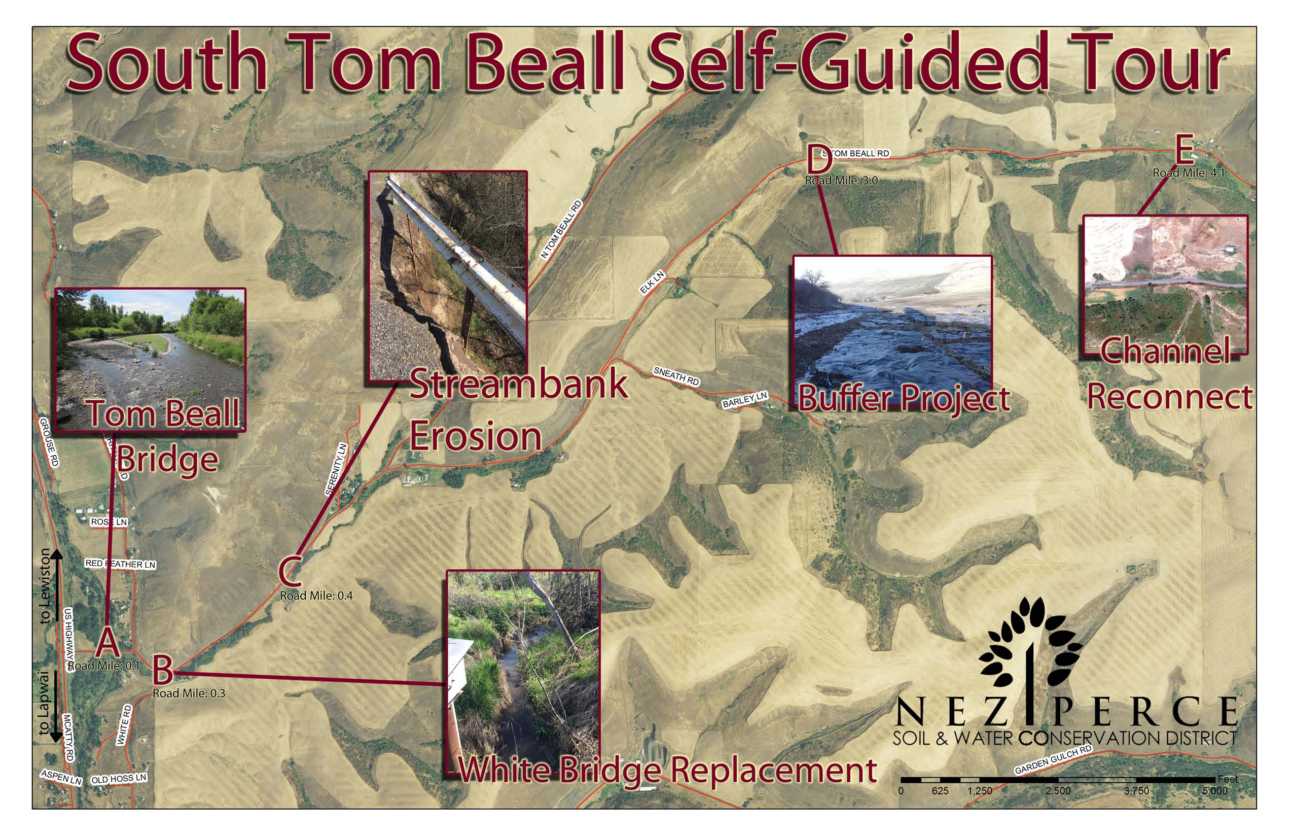
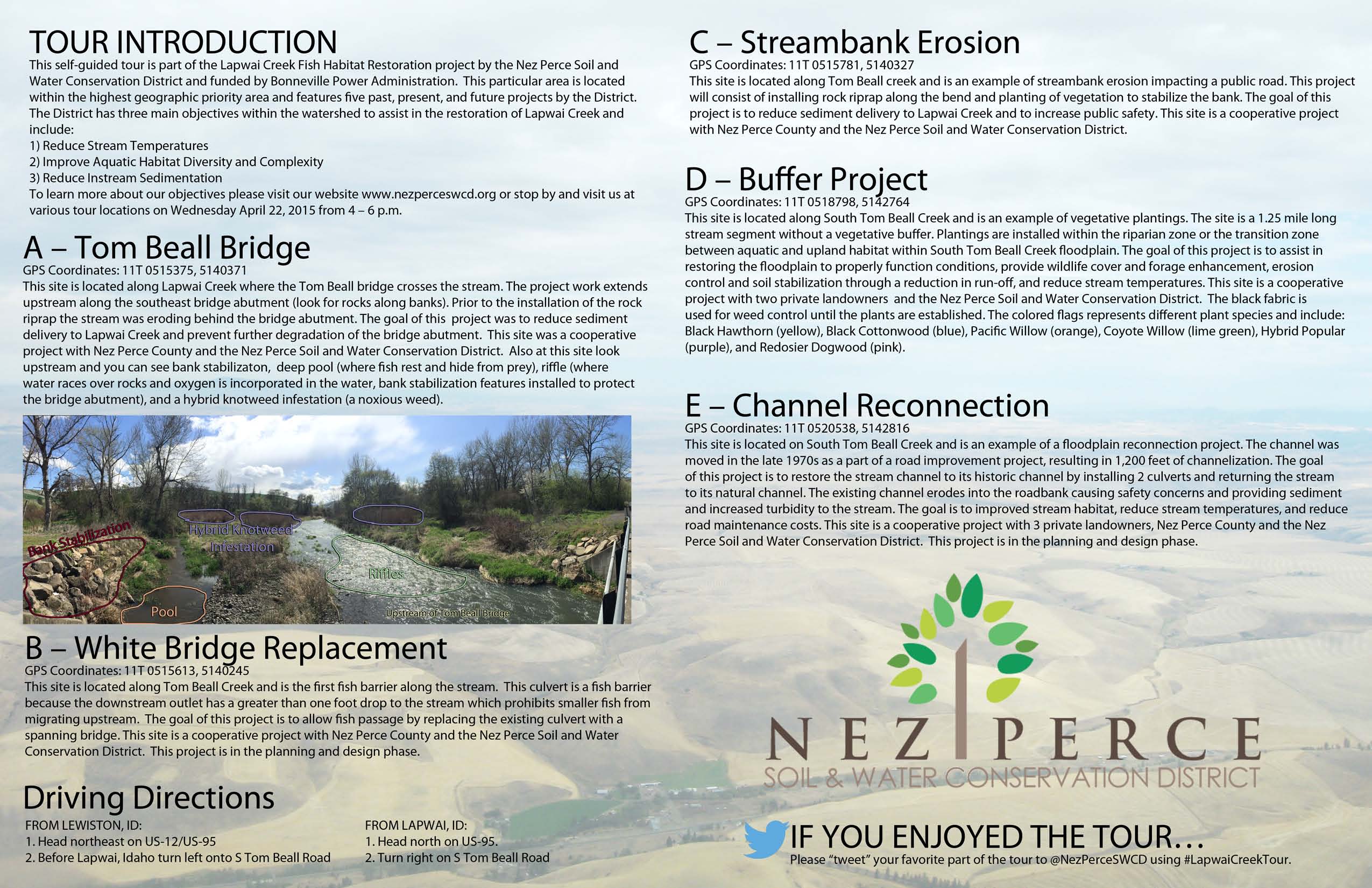
A – Tom Beall Bridge
GPS Coordinates: 11T 0515375, 5140371
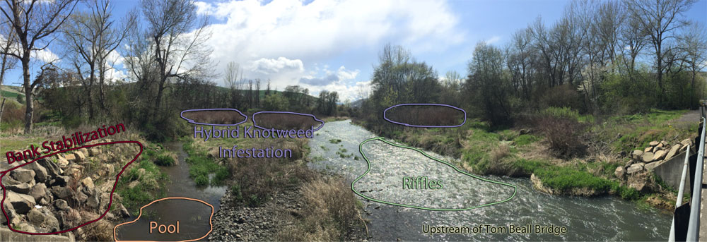
This site is located along Lapwai Creek where the Tom Beall bridge crosses the stream. The project work extends upstream along the southeast bridge abutment (look for rocks along banks). Prior to the installation of the rock riprap the stream was eroding behind the bridge abutment. The goal of this project was to reduce sediment delivery to Lapwai Creek and prevent further degradation of the bridge abutment. This site was a cooperative project with Nez Perce County and the Nez Perce Soil and Water Conservation District. Also at this site look upstream and you can see bank stabilizaton, deep pool (where fish rest and hide from prey), riffle (where water races over rocks and oxygen is incorporated in the water, bank stabilization features installed to protect the bridge abutment), and a hybrid knotweed infestation (a noxious weed).
Tom Beall Bridge Photo Diagram
B – White Bridge Replacement
GPS Coordinates: 11T 0515613, 5140245
This site is located along Tom Beall Creek and is the first fish barrier along the stream. This culvert is a fish barrier because the downstream outlet has a greater than one foot drop to the stream which prohibits smaller fish from migrating upstream. The goal of this project is to allow fish passage by replacing the existing culvert with a spanning bridge. This site is a cooperative project with Nez Perce County and the Nez Perce Soil and Water Conservation District. This project is in the planning and design phase.
C – Streambank Erosion
GPS Coordinates: 11T 0515781, 5140327
This site is located along Tom Beall creek and is an example of streambank erosion impacting a public road. This project will consist of installing rock riprap along the bend and planting of vegetation to stabilize the bank. The goal of this project is to reduce sediment delivery to Lapwai Creek and to increase public safety. This site is a cooperative project with Nez Perce County and the Nez Perce Soil and Water Conservation District.
D – Buffer Project
GPS Coordinates: 11T 0518798, 5142764
This site is located along South Tom Beall Creek and is an example of vegetative plantings. The site is a 1.25 mile long stream segment without a vegetative buffer. Plantings are installed within the riparian zone or the transition zone between aquatic and upland habitat within South Tom Beall Creek floodplain. The goal of this project is to assist in restoring the floodplain to properly function conditions, provide wildlife cover and forage enhancement, erosion control and soil stabilization through a reduction in run-off, and reduce stream temperatures. This site is a cooperative project with two private landowners and the Nez Perce Soil and Water Conservation District. The black fabric is used for weed control until the plants are established. The colored flags represents different plant species and include: Black Hawthorn (yellow), Black Cottonwood (blue), Pacific Willow (orange), Coyote Willow (lime green), Hybrid Popular (purple), and Redosier Dogwood (pink).
E – Channel Reconnection
GPS Coordinates: 11T 0520538, 5142816
This site is located on South Tom Beall Creek and is an example of a floodplain reconnection project. The channel was moved in the late 1970s as a part of a road improvement project, resulting in 1,200 feet of channelization. The goal of this project is to restore the stream channel to its historic channel by installing 2 culverts and returning the stream to its natural channel. The existing channel erodes into the roadbank causing safety concerns and providing sediment and increased turbidity to the stream. The goal is to improved stream habitat, reduce stream temperatures, and reduce road maintenance costs. This site is a cooperative project with 3 private landowners, Nez Perce County and the Nez Perce Soil and Water Conservation District. This project is in the planning and design phase.
Figure 14. South Tom Beall Self-Guided Tour Descriptions