River canyon
Menu
  1. Home
  2. Documents
  3. Programs
  4. Projects
  5. Watersheds
  6. About Us
User Menu Search
Close

Craig Mountain Orange Hawkweed Mapping

Project Description:

Null

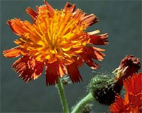
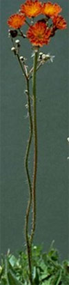
The project consists of an inventory and treatment phase for orange hawkweed. Treatment sites are located in the Mission Creek, Lapwai Creek, and Sweetwater Creek drainages. The treatment site consists of approximately 15 acres owned by 2 private landowners. The site was inventoried and mapped in the summer of 2008 and 2009. The landowner will treat the weeds. The inventory phase is for two adjacent landowner parcels where the weed has been spotted. The inventory will identify the extent and the location of the orange hawkweed and result in a treatment plan for 2011.

NPSWCD recognizes that control of invasive plants species in potential restoration areas needs to occur prior to any further restoration activities.

This project is a partnership effort with the Idaho Department of Agriculture, Clearwater Basin Cooperative Weed Management Area, the Nez Perce Soil and Water Conservation District and the Bonneville Power Administration.

The project addresses the following goals from the Clearwater Basin Weed Management Area strategy:

Goals from the CBWMA strategy:

Null

The following goals from the CBWMA strategy (A Strategy for Invasive Plant Management in the Clearwater River Basin - November, 2002) are addressed with this proposal.

  • Prevent the introduction, reproduction, and spread of noxious weeds and invasive plants into and within the Clearwater River Basin.
  • Eradicate new outbreaks of established invasive plants.
  • Reduce the density of established noxious weeds and invasive plants to a point that natural resource damage is within acceptable limits.
  • Implement the most economical and effective control methods for the target species.

This proposal addresses the following management priorities listed in the CBWMA strategy (2002):

4th Control noxious weeds or invasive plants along transportation corridors and areas of concentrated activities, such as roads, trails, campgrounds, trailheads parking lots and gravel pits
Specific Relationship: Control orange hawkweed along logging roads.

6th Contain established noxious weeds and invasive plants
Specific Relationship: Noxious weeds and invasive plants are geographically contained and are not increasing beyond the perimeter of the infestation. Orange hawkweed is contained to current geographic area. Treatment reduces ability of invader to spread to other areas.

7th Reduce the density or slow the spread of widespread established invaders
Specific Relationship: Invasive weed density and rate of spread will be reduced as a result of treating identified areas.

2018 Inventory and Treatment

A total of 2,794 acres was inventoried in 2018 on eight private landowner parcels. Of these 41.7 acres included orange hawkweed and was treated.

Figure 1. Treatment Map.

Null

2017 Inventory and Treatment

A total of 508 acres was inventoried in 2017 on one private landowner parcel. Of these 0.3 acres included orange hawkweed. A total of 44.602 acres were treated with herbicides in 2017 on nine private parcels

Figure 1. Treatment Map.

Null

2016 Inventory and Treatment

A total of 560 acres of private land was inventoried in 2016 (figure 1). Of these 0.43 acres of hawkweed were found. A total of 13 acres of hawkweed were treated in 2016 on properties previously identified for hawkweed infestations.

Figure 1. Inventory Map.

Null

2015 Inventory and Treatment

A total of 520 acres of private land was inventoried in 2015 (figure 1). Of these 0 acres of hawkweed were found. A total of 11.6 acres of hawkweed were treated in 2015 on properties previously identified for hawkweed infestations.

Figure 1. Inventory Map.

Null

2014 Inventory and Treatment

A total of 240 acres of private land was inventoried in 2014 (figure 1). Of these 0 acres of hawkweed were found. A total of 118 acres of hawkweed were treated in 2014 on properties previously identified for hawkweed infestations.

Figure 1. Inventory Map.

Null

2013 Inventory and Treatment: Mission Creek Area

Results

A total of 359 acres were inventoried in 2013 (figure 1). Of these 40.53 acres (11%) included orange hawkweed. Table 1 includes the results of this inventory.

Table 1. 2013 inventory summary

Inventory parameter
Acres
Disturbance
A= Agriculture
0 Acres
R= Roads
0.170 Acres
G= Grazing
40.360 Acres
OTH= Other
0 Acres
Abundance
A= Single Plant
0 Acres
B=Less than 20
0.004 Acres
C= 20-99
0.008 Acres
D= 100-999
0.125 Acres
E= More than 100
39.72 Acres
Distribution
A= Infrequent Occurrence
0.014 Acres
B= Evenly Throughout
1.495 Acres
C= Localized Patches
38.118 Acres
D= Frequent Stands
0.904 Acres
E= Densely throughout
0 Acres
Stage
B= Berries/Fruit
0 Acres
F= Flower
39.95 Acres
L= Leaves
0 Acres
O= Other
0.583 Acres

Figure 1. Inventory Map

Null

2012 Inventory and Treatment: Webb Creek Area

Background

The orange hawkweed inventory and control project began in 2009. The project includes two components; A) orange hawkweed inventory and B) orange hawkweed control. The goal is to identify orange hawkweed infestations within the forestland grazing areas of the Craig Mountain, Lapwai Creek, and Big Canyon Creek drainages. The project is funded by the Idaho Department of Agriculture and the Bonneville Power Administration.

Methods

The inventory is completed following the District’s Hawkweed Inventory Procedure1. Data is collected by disturbance type, abundance, distribution, and plant stage.

Results

A total of 267 acres were inventoried in 2012 (figure 1). Of these 0.56 acres included orange hawkweed. Table 1 includes the results of this inventory. The District’s newsletter included articles pertaining to orange hawkweed and was distributed to 2,000 individuals.

Table 1. 2012 inventory summary

Inventory parameter
Acres
Disturbance
A= Agriculture
0 Acres
R= Roads
0 Acres
G= Grazing
0.56 Acres
OTH= Other
0 Acres
Abundance
A= Single Plant
0 Acres
B=Less than 20
14 square feet
C= 20-99
187 square feet
D= 100-999
0.2 Acres
E= More than 100
0.34 Acres
Distribution
A= Infrequent Occurrence
0 Acres
B= Evenly Throughout
0.35 Acres
C= Localized Patches
0.15 Acres
D= Frequent Stands
0.06 Acres
E= Densely throughout
0 Acres
Stage
B= Berries/Fruit
0.48 Acres
F= Flower
0.44 Acres
L= Leaves
0.49 Acres

Treatment

A total of 4 acres of hawkweed was treated by spot spraying with backpack sprayers.

Figure 1. 2012 Inventory Map

Null

1 The Nez Perce Soil and Water Conservation District Hawkweed Inventory procedure working draft 7/2010 is adapted from the U.S. Fish & Wildlife Service web site.

2011 Inventory: Webb Creek Area

Purpose / Goal / Procedure

The orange hawkweed inventory and control project began in 2009. The project includes two components; A) orange hawkweed inventory and B) orange hawkweed control. The goal is to identify orange hawkweed infestations within the forestland grazing areas of the Craig Mountain, Lapwai Creek, and Big Canyon Creek drainages. The project is funded by the Idaho Department of Agriculture and the Bonneville Power Administration.

Methods

The inventory is completed following the District’s Hawkweed Inventory Procedure1. Data is collected by disturbance type, abundance, distribution, and plant stage.

Results

A total of 835.7 acres were inventoried in 2011 (figure 1). Of these 115.47 acres included orange hawkweed. Table 1 includes the results of this inventory.

Table 1. 2011 inventory summary

Inventory parameter
Acres
Disturbance
A= Agriculture
.0006 Acres
R= Roads
.19 Acres
G= Grazing
113.21 Acres
OTH= Other
2.07 Acres
Abundance
A= Single Plant
.002 Acres
B=Less than 20
2.52 Acres
C= 20-99
8.04 Acres
D= 100-999
41.43 Acres
E= More than 100
63.48 Acres
Distribution
A= Infrequent Occurrence
.51 Acres
B= Evenly Throughout
43.77 Acres
C= Localized Patches
32.77 Acres
D= Frequent Stands
23.18 Acres
E= Densely throughout
15.24 Acres
Stage
B= Berries/Fruit
.10 Acres
F= Flower
115.37 Acres
L= Leaves
O= Other

Treatment

A total of .6 acres of hawkweed treated by spot spraying.

Figure 1. 2011 Inventory Map

Null

1The Nez Perce Soil and Water Conservation District Hawkweed Inventory procedure working draft 7/2010 is adapted from the U.S. Fish & Wildlife Service web site.

2010 Survey: Webb Creek Area

The District will be conducting an Orange Hawkweed survey this summer. The surveys will begin west of the Webb Ridge road and end at the Fountain Grade Road. The surveys will be conducted in July and August with crews surveying for about two weeks.

After the surveys are completed and priority areas are determined, the District plans to utilize the survey information to develop a treatment plan for implementation in 2011.

Null

2009 Survey: Webb Creek

The District conducted an Orange Hawkweed inventory on about 3 miles of a tributary to Webb Creek. This survey identified low to medium density populations of orange hawkweed. District staff and the landowners will treat these locations in the fall of 2010.

For more information regarding the survey:
Phone: 208-843-2931
E-mail NPSWCD

Follow the links to the orange hawkweed profiles to learn more about each species

Orange Hawkweed photos from Washington State Noxious Weed Control Board.

Terms Of UsePrivacy StatementCopyright 2024 by Nez Perce County
Back To Top