This project replaced the existing Bear Creek Bridge (40 foot opening, 2.3 feet clearance) with a pre-fabricated structure that is 50 feet long and has 5 feet of stream clearance. The larger structure is needed to accommodate spring runoff events, prevent flooding damage, reduce debris accumulation and stabilize abutments. The project is located along Bear Creek, approximately 1.5 miles upstream from the confluence of Big Canyon Creek and the Clearwater River. This creek has perennial flow and is spring fed. Bedload was deposited on the upstream side the old bridge and created an annual flooding hazard within the channel and on Big Canyon Creek Road. The old structure lacked the capacity to pass annual spring runoff events and accumulated gravels upstream and under the structure, which reduced the capacity of the channel and diverted flood waters over the road surface. This site had been a concern since the early 1990s. The bridge replacement was finished in fall 2019. One rock weir was placed upstream of the new bridge to improve channel function. The stream was revegetated with a combination of grass, trees, and shrubs, and the area received weed treatment.
This project provides a direct benefit to the residents of Peck, Idaho by reducing the flooding, erosion and debris deposition and subsequent flooding threats that occur on an annual basis. Big Canyon Creek Road provides access to Highway 12 for about 200 residents of the City as well as surrounding rural residents.
It also serves as a reopening of fish passage to the creek. The Bear Creek Barrier Removal Phase 2 project, located in the Big Canyon Creek watershed, removed a fish passage barrier to open 2.1 miles to steelhead passage during all life stages. One rock weir was placed upstream of the new bridge to improve channel function. The riparian area was revegetated with a combination of grass, trees, and shrubs, and the area received weed treatment. Bear Creek is approximately 1.5 miles upstream from the confluence of Big Canyon Creek and the Clearwater River. The project is located in a known spawning area, has perennial flow, and good habitat conditions upstream and downstream of the site. This project removed the only passage barrier identified in Bear Creek.
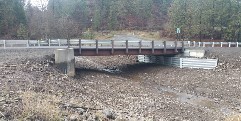
Completed new bridge and channel (2019).