Location
Lindsay Creek (hydrologic unit # 17060306) is located in the Clearwater River hydrologic basin. The size of the watershed is 14,200 acres. Lindsay Creek flows in a northwesterly direction from Mann Lake joining with the Clearwater River near Lewiston, Idaho. (Figure 1).
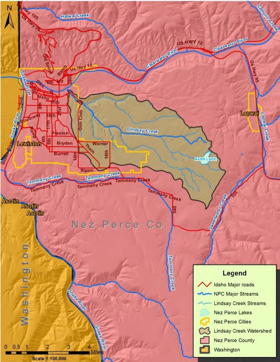
Figure 1. Lindsay Creek Location Map.
Elevations range from 750 feet at the confluence to 1,800 feet at the headwaters. The stream flows through farmland in the upper reaches and then through a canyon until it passes through a tunnel through the Clearwater levee built by the Army Corps of Engineers.
Ownership
The majority of the land within the watershed is privately owned (96 %). Table 1 delineates the extent of ownership, while Figure 2 maps ownership in the watershed.
Table 1. Lindsay Creek watershed ownership.
| Ownership | Acres | Percentage (%) |
| Private | 13,635 | 96 |
| Tribal | 562 | 4 |
| Federal | 0 | 0 |
| State | 13 | <1 |
| Total | 14,200 | 100 |
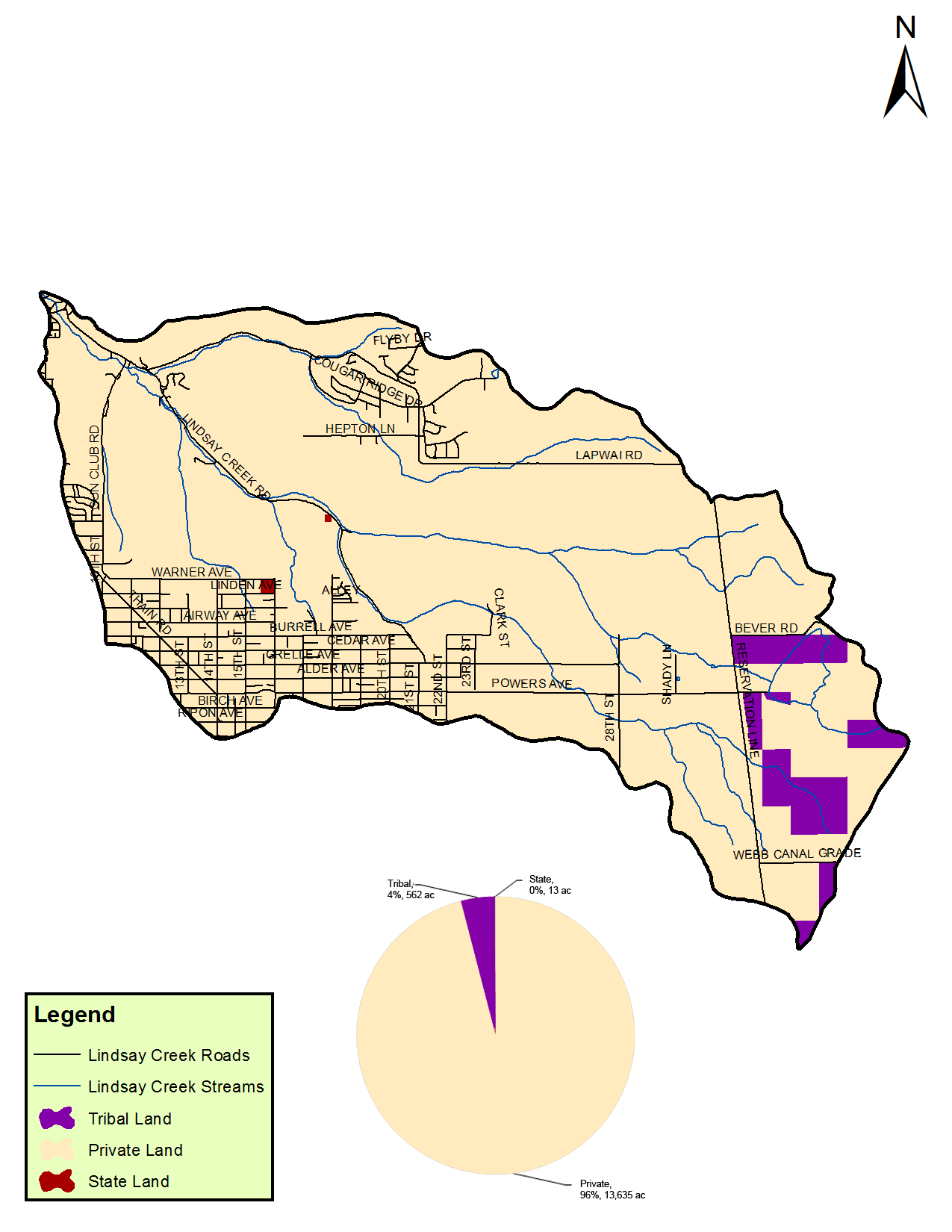
Figure 2. Ownership map.
Climate
The Lindsay Creek watershed has a maritime climate pattern characterized by cool moist winters and warm dry summers. This climate is typical for much of the Pacific Northwest, Columbia and Clearwater basins and results from air masses and storm systems moving inland from the Pacific Ocean. Average annual precipitation increases with elevation, ranging from approximately 14 inches in the lower portions of the watershed to about 21 inches in the higher elevation areas (figure 3).
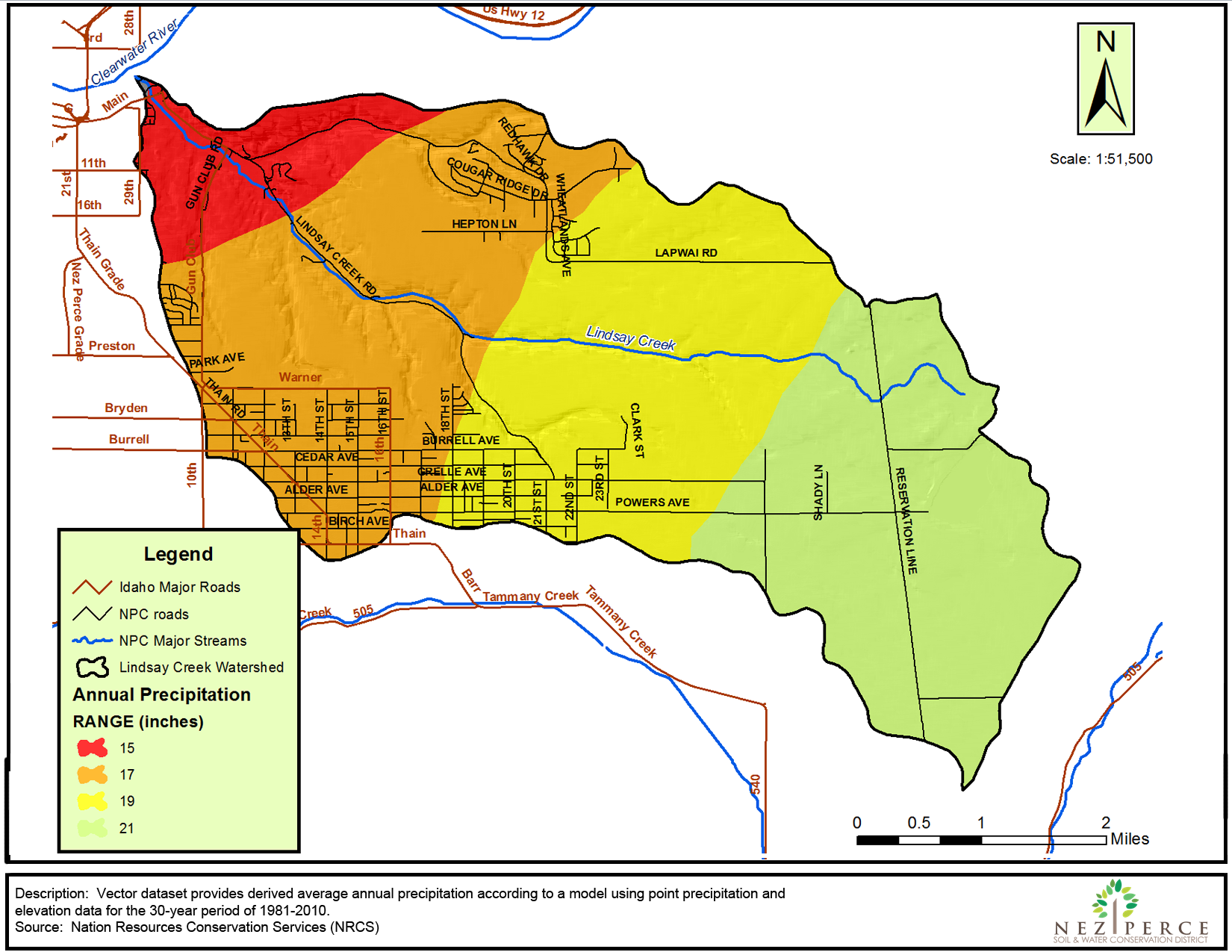
Figure 3. Precipitation zones.
Geology and Lithology
The geology of the watershed is characterized into five units.
Unit 1: Loess (Holocene and Pleistocene) Loess soil extends to the upper plateau of the Lindsay Creek watershed and eastern sections of the Lewiston Orchards, occupying approximately 72% of the watershed. The soil is composed of calcareous wind-blown silt, sandy near deposits of the Lake Missoula Floods. Composition partly correlates with the Palouse Formation; however, it lacks the distinctive Palouse Hills of the eastern Columbia group, and is composed of a single late Pleistocene deposit. Exposures show one to several layers that represent periods of rapid depositions of air-borne dust. The thickest layers of loess material may have formed immediately after the Lake Missoula Floods backwater events in the Clearwater and Snake River valleys. Soil thickness is 5 to 20 feet and may be greater than that on some north-facing slopes where it is thickened by wind drift and where vegetation prevents erosion.
Unit 2: Alluvium of Side Streams (Holocene) This unit is composed of channel and flood-plain deposits of tributaries to the Clearwater River. It consists primarily of coarse gravels deposited during high-energy stream flows, with subrounded to rounded boulders, cobbles, and pebbles of basalt in a sand matrix. It includes intercalated colluvium and debris-flow deposits from steep side slopes. Soils developed inside-stream alluvium include the Bridgewater and Lapwai soil series.
Unit 3: Colluvium from Basalt (Holocene and Pleistocene) These areas contain primarily poorly sorted brown muddy gravel composed of angular and subangular boulders, cobbles, and pebbles of basalt in a matrix of silt and clay. Deposits have been emplaced by gravity movements on steep-sided canyons and gullies cut into Columbia River basalt. Steep, dry, southerly aspects commonly contain outcrops of basalt where colluvium is thinner and the more erosion-resistant basalt flows from laterally traceable edges. More gently sloping areas are covered with thin loess, typically 1-5 feet thick, particularly close to boundaries with loess units.
Unit 4: Alluvium and Colluvium (Holocene) Areas within this unit consist of stream, slope-wash, and gravity deposits. Predominately beds of silt, clay, and sand received through the erosion of bordering depositional units. Stream deposits are characteristically thin and interfinger with laterally thickening deposits of slope wash and colluvium derived from local loess deposits and weathered basalt. Soils developed in these deposits include the Broadax and Slickpoo series.
Unit 5: Landslide Deposits (Holocene and Pleistocene) This unit contains poorly sorted and poorly stratified angular basalt cobbles and boulders with silt and clay. Landslide deposits include debris slides as well as blocks of basalt, sedimentary interbeds that have been rotated and moved laterally. Debris slides mainly composed of unstratified, unsorted gravel rubble in a clayey matrix.
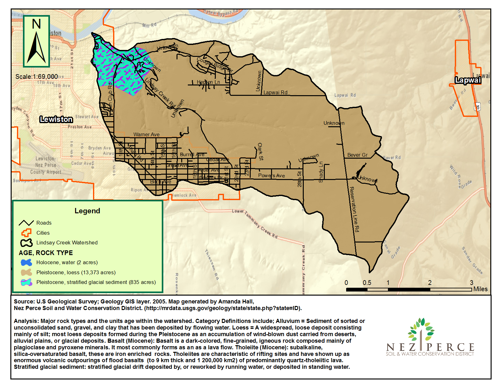
Figure 4. Geology map.
Soils
Twelve soil series are identified for the Lindsay Creek watershed. They include (descending order by acreage): Broadax-Hatwai Complex (43%), Oliphant Silt Loam (25%), and chard Silt loam. Figure 5 illustrates coverage of each soil series.
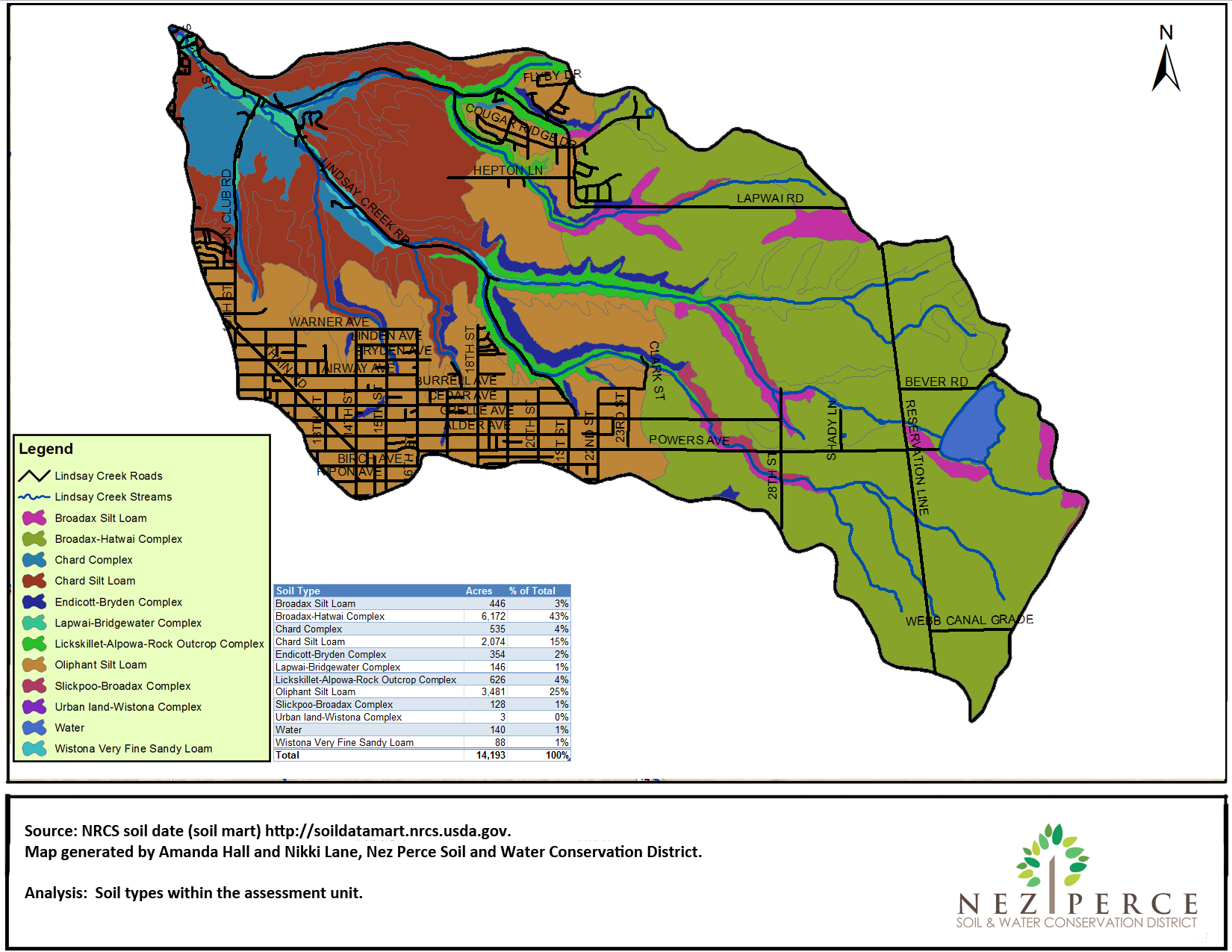
Figure 5. Soils map.
Land Cover
Land cover within the watershed, as displayed in Table 6, is divided into ten categories according to land cover GIS data provided by the GAP Analysis (Figure 11). Dominant land cover coincides with the dominant land use, with 61% of the watershed covered by cultivated crops.
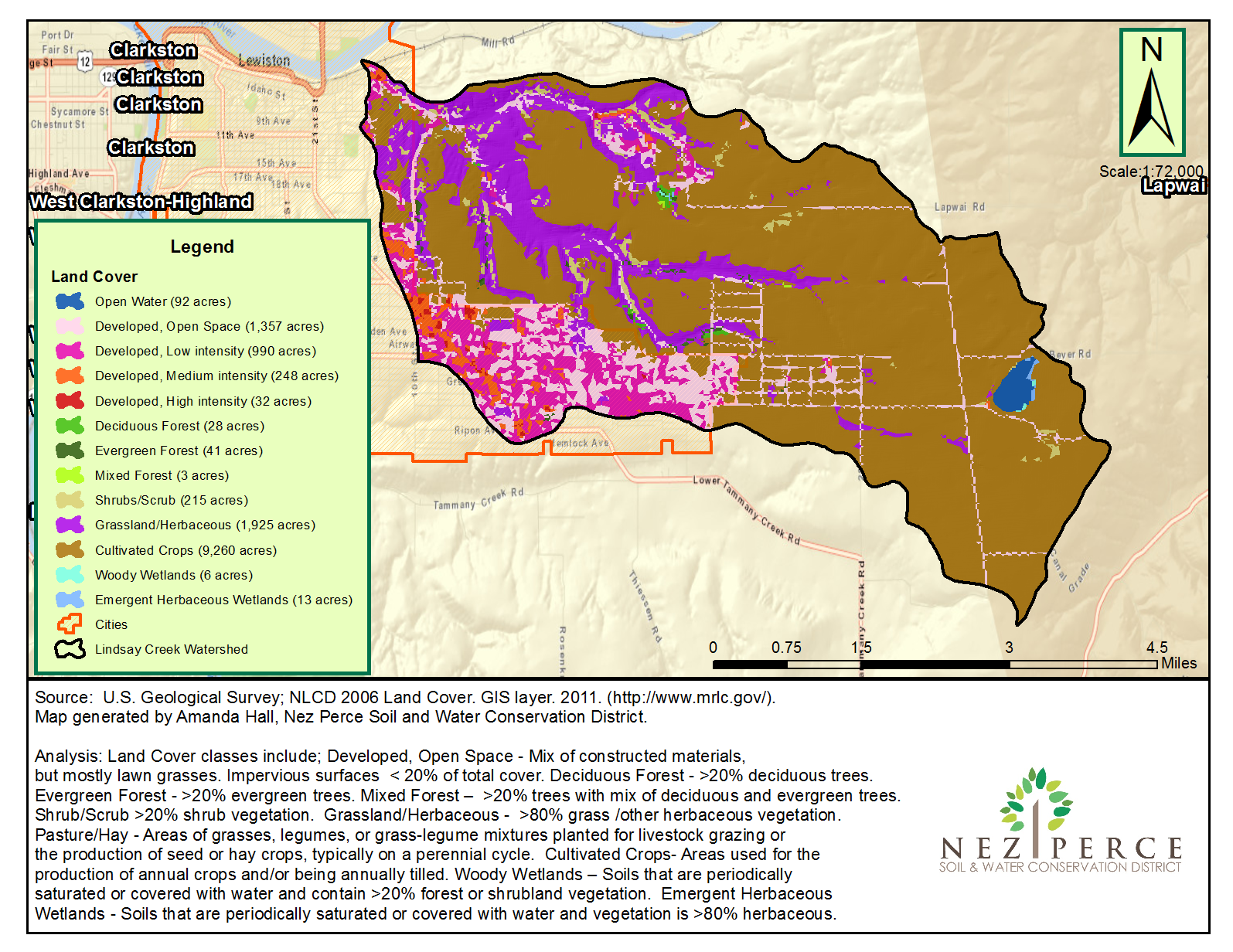
Figure 6. Landcover map.
Table 7. Lindsay Creek land cover extent.
| Cover Type | Acres | % |
| Cultivated Crops | 9,260 | 65.0 |
| Developed, Low Intensity | 990 | 6.9 |
| Developed, Open Space | 1,357 | 9.5 |
| Developed, Medium Intensity | 248 | 1.7 |
| Developed, High Intensity | 32 | 0.2 |
| Forest and Woodland | 72 | 0.5 |
| Open water | 92 | 0.6 |
| Grassland | 1,925 | 13.5 |
| Semi Dessert Shrubland | 60 | 0.4 |
| Shrubs and Scrub | 215 | 1.5 |
| Total | 14,251 | 100 |
Wetlands
The US Fish and Wildlife National Wetlands Inventory identifies 233 acres of wetlands within the watershed (Figure 7).
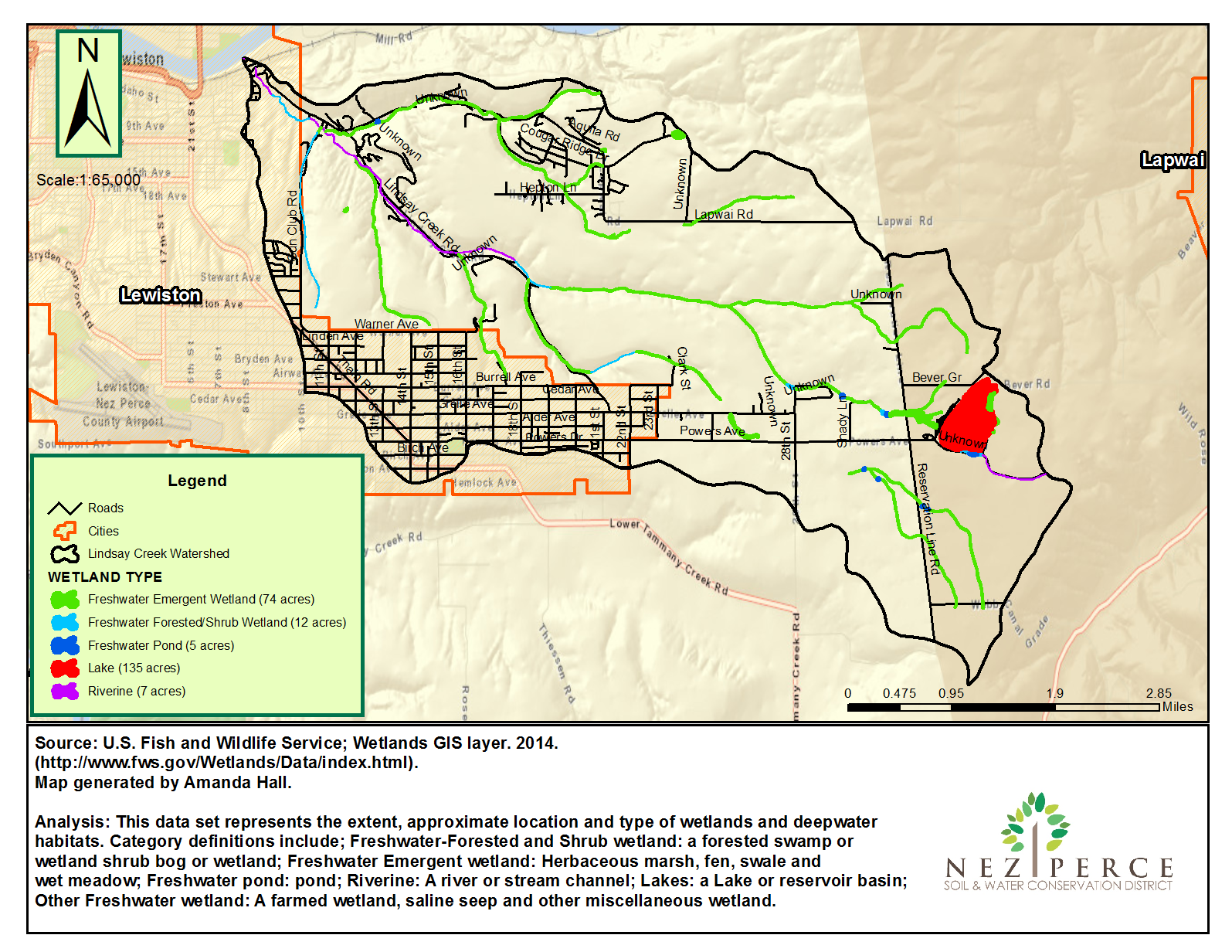
Figure 7. Wetlands Location.
Roads
Road density of the Lindsay Creek drainage averages 3.31 miles road/square mile. Over 111 miles of roads exist within the watershed. Of these, 48% are dirt, 52% are gravel, and less than 1% is paved (Figure 7).
A road erosion inventory and assessment was completed in 2015.
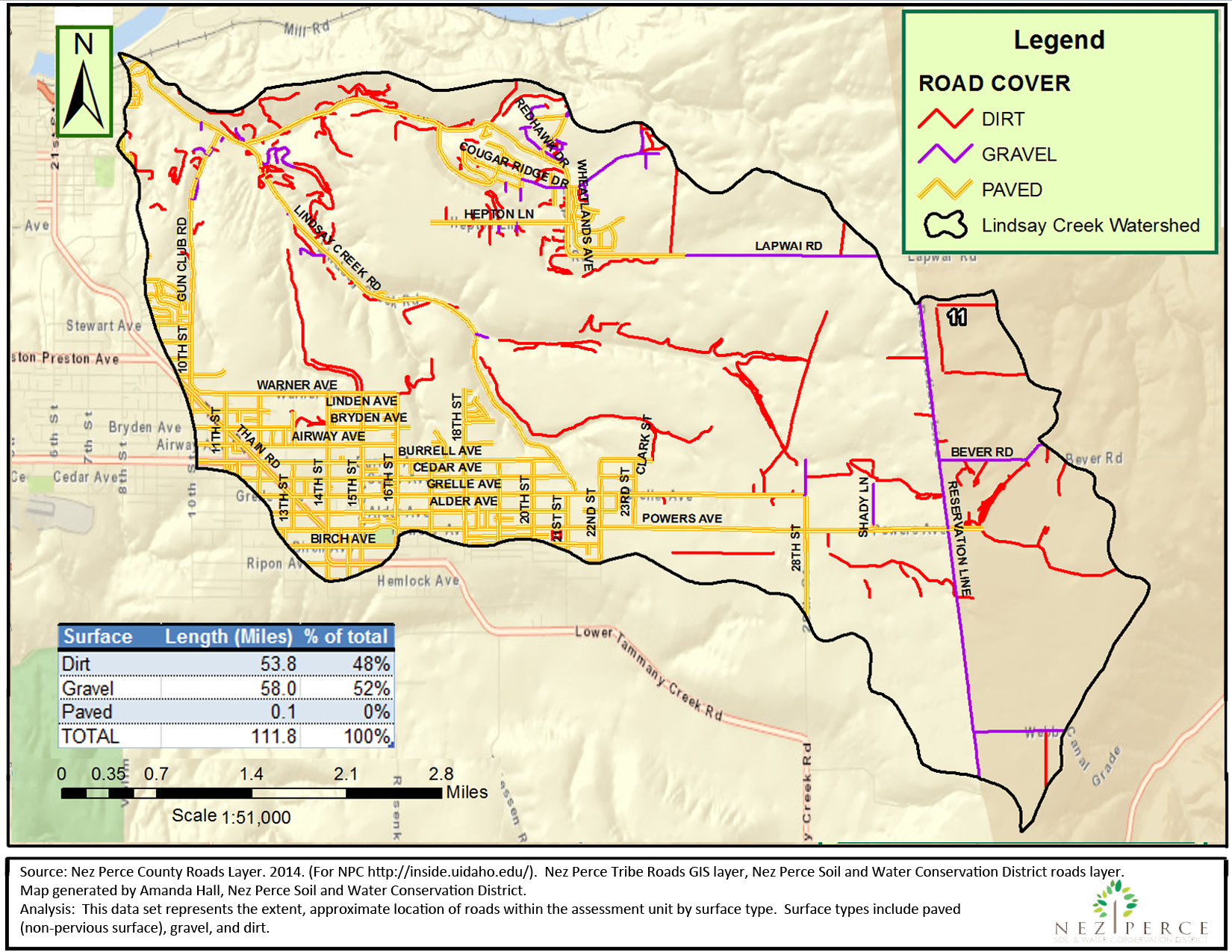
Figure 8. Road Surface Types.
Structures
Over 2,800 structures are located within the watershed. Of these 8% are located within 150 feet of the stream (Figure 8).
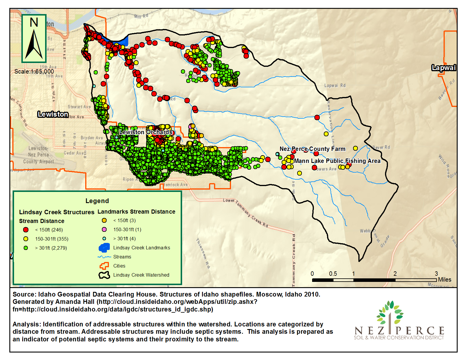
Figure 9. Structure Proximity to the Stream.
Fish Status
The IDEQ identifies Rainbow trout and speckled Dace during a 1995 survey of the stream.