Waters with high concentrations of suspended sediment result in high levels of turbidity, which can delay fish migration. Excessive amounts of sediment can embed cobble and gravel, reducing the amount of available spawning substrate. Natural events, such as landslides or wildfires, can contribute to high turbidity, as can unnatural and man-made events, such as poor road placement, dredging upland channels for drainage, and diversions.
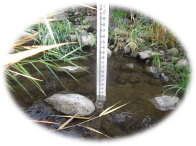
Figure 1. Lapwai Creek Turbidity Sampling
Sediment loading is related to the other limiting factors, like habitat diversity and flow. Restoration efforts designed to improve bank stability, floodplain connectivity, channel configuration and holding capacity will necessarily improve sediment transport and deposition. Better culverts, armored road ditches and more extensive road maintenance will also help reduce excess sediment inputs.
Lapwai Creek fish habitat and water quality are impacted by sediment. Sediment sources within the watershed are upland lands, roads, and stream banks.
Objective 3 – Reduce Instream Sediment
One of the three objectives identified in the Restoring Anadromous Fish in the Lapwai Creek Watershed plan is to decrease sediment load.
Objective Description:
Reduce instream sedimentation to levels meeting applicable water quality standards, with an established upward trend in the number of stream miles meeting standards. Benchmarks for this activity include streambanks are >90% stable, < 20% cobble embeddedness, and turbidity is low (NOAA, 1996).
Additional benchmarks for specific project types are discussed under relevant deliverables. Desired outcomes include restoring streambank condition, reducing sediment delivery to the stream from hydrologically connected roads and uplands, and reducing sediment inputs by implementing practices that address problems from logging, mining, agricultural and other historic and current sediment producing activities. This been reduced by anthropogenic activities. This objective is consistent with the Clearwater Subbasin Management Plan, pg 35 (NPCC, 2005).
Deliverables:
In order to meet the objectives the following deliverables or treatments are identified:
Deliverable 2 – Reduce Streambank Erosion-
The amount of fine sediment present in, or passing through, a stream reach effects the relative survival or performance of fish species. This limiting factor is important during spawning, incubation and rearing.
Waters with high concentrations of suspended sediments result in high levels of turbidity, which can delay migration. Excessive amounts of sediment can embed free matrix cobble and gravel, reducing the amount of available spawning substrate. Additionally, sedimentation in areas where redds have been created can cause suffocation of eggs prior to emergence and reduce available interstitial substrate space for juvenile cover. Natural events, such as landslides or wildfires can contribute to high turbidity, as can unnatural and man-made events, such as poor road placement, logging or trans-basin diversion. Although data regarding total suspended solids and turbidity is spatially and temporally inconsistent within the basin, surveys performed by the NPT in 2003 and 2006 indicated moderate to severe impairment of bank stability throughout all 16 sites over both sample years. This is likely to contribute to the overall levels of turbidity and suspended solids.
While a small amount of cobble embeddedness data has been compiled throughout the Lapwai Creek watershed, the physical parameters required in order to collect acceptable cobble embeddedness samples are very narrow, resulting in a 50% survey rate of sites in 2003 by the NPT and a 56% survey rate in 2006. In 2003, of the sites surveyed, 62.5% showed highly impaired conditions and 25% showed moderate impairment. In 2006, 57% indicated high impairment and an additional 29% were considered moderately impaired. A complete description of methods and results are available by request from the NPT.
Juvenile salmonids tend to avoid streams with regular high turbidity, which can disrupt feeding and territorial behavior. Typically, juvenile fish are not significantly impacted by low or infrequent levels of turbidity, such as those that occur following a storm event. Favorable turbidity levels for juvenile salmonids are < 50 NTU for newly emerged fry and <60 nephelometric turbidity units (NTU) for older fry and parr (Bjornn and Reiser, 1991).
Planned: 1.1 miles of streambank stabilization plan development; 800 LF streambank protection.
Deliverable 3 – Reduce Road Related Sediment Delivery to the Stream
Treatments to address sediment input from roaded areas include the following: slope stabilization, shaping, water relief structures, and regular, appropriately timed maintenance. We demonstrated two road drainage techniques used by the Forest Service; rubber belting water bars and open topped culverts. We wanted to evaluate these techniques for use on cropland field access roads. These projects are discussed in detail under the project highlight section. Preliminary monitoring data indicates the rubber belting type was the most effective for achieving sediment reductions. A final analysis will occur in 2013 and results will be shared through PISCES.
Planned: 1.5 road improvements; 5.0 miles road improvements planned.
Deliverable 4 – Reduce Sediment Delivery to Streams from Uplands
Reduce sediment inputs by implementing practices that address problems from logging, mining, agriculture and other historic and current sediment producing activities.
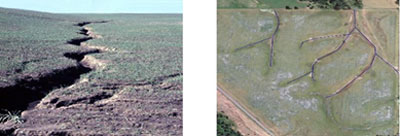
| Figure 9. Gully Erosion | Figure 10. Gully Erosion Overview |
Planned: 120 acres of upland treatments.
Deliverable 5 – Remove or Retrofit Fish Barriers
Remove or modify human-caused barriers--emphasize alteration/removal of barriers so that fish passage occurs at all flows.
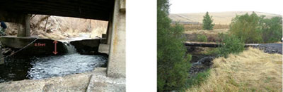
| Figure 18. Before Construction | Figure 19. After Construction |
Planned: Remove 3 barriers restoring 1.25 miles of access.
Deliverable 6 – Restore Floodplain Access and Reconnect Channel
Planned: Complete 7.6 miles of floodplain analysis; restore aquatic habitat suitability to 1,200 feet of stream channel.