Details provided in this section were obtained from the Catholic Creek Watershed Management Plan.
Location
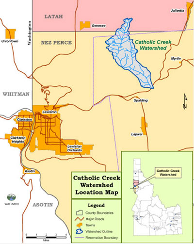
Catholic Creek is a second order tributary entering the Clearwater River approximately 13 miles upstream from the confluence of the Clearwater River and the Snake River near Lewiston, Idaho. Located partially within the Nez Perce Indian Reservation, the watershed drains approximately 7,776 acres or 12.15 square miles. The watershed encompasses portions of both Latah, (8%-633 acres), and Nez Perce, (92%-7,143 acres), Counties, Idaho (Figure 1). The watershed is a small portion of the 9,645 square mile Clearwater River subbasin, which is one of the most biologically rich and diverse drainages in the Columbia River basin. The subbasin was stratified into eight regional units with shared biophysical properties during the Northwest Power and Conservation Council’s subbasin planning process. Catholic Creek is in the lower Clearwater assessment unit (Ecovista 2002).
Figure 1. Catholic Creek location map
Ownership
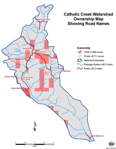
The majority of the land within the watershed is privately owned (86 %). Table 4 delineates the extent of ownership, while Figure 2 maps ownership in the watershed.
Table 4. Catholic Creek watershed ownership.
| Ownership Type | Acres | Percentage (%) |
| Private | 6,711 | 86 |
| Tribal | 1,065 | 14 |
| Federal | 0 | 0 |
| State | 0 | 0 |
| Total | 7,776 | 100 |
Climate
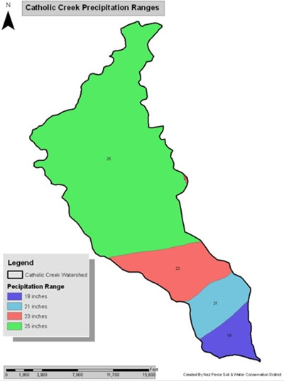
The Catholic Creek watershed has a maritime climate pattern characterized by cool moist winters and warm dry summers. This climate is typical for much of the Pacific Northwest, Columbia and Clearwater basins and results from air masses and storm systems moving inland from the Pacific Ocean. Average annual precipitation increases with elevation, ranging from approximately 19 inches in the lower portions of the watershed to about 25 inches in the higher elevation areas (figure 3). Such an elevation gradient in precipitation is typical in this region. The nearest long-term climatic stations are located in Lewiston and Moscow, Idaho. The Lewiston station best represents the lower climatic conditions while the Moscow station best represents the upper part of Catholic Creek watershed.
Figure 3. Precipitation zones.
Topography
The plateau comprising much of the lower Clearwater has a moderately sloping terrain with local elevations ranging from 2,500 to 3,500 feet and some isolated buttes reaching elevations of 5,000 feet. Side slopes within the plateau range from 0% to 15% with some stream valleys having side slopes exceeding 60%. The mouth of Catholic Creek is approximately 800 feet above mean sea level. Catholic Creek extends through a fairly steep canyon area onto the Palouse Prairie, where slopes are more moderate, to an elevation of approximately 2900 feet.
Geology and Lithology
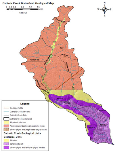
Catholic Creek is located within the Columbia Plateau basalt flows which started forming about 16 million years ago (Figure 4). Basalt flows are typically 300 to 2,000 feet thick. The basalt flows are underlain by the Continental margin gray diorites. In the northern and middle portions of the watershed that are less sloping, loess overlays the basalt, forming a thick mantle of highly fertile soils. Loess is a windblown material that covers much of the Palouse Prairie.
Basalt formations influence the surface and groundwater flow. Basalt flows are mostly resistant to weathering and groundwater alterations. These formations break into un-weathered basalt fragments. Groundwater in basalt formations is stored and flows within the open spaces. Soil characteristics, coupled with local land use and climate patterns, make rill and sheet erosion a substantial issue. The loess is easily eroded, especially on steeper slopes that are left unprotected during rainfall events. In some areas the subsoil freezes, topsoil becomes saturated and moves laterally over the subsoil creating slumps and new landforms (Kaufman et. al. 2009).
Figure 4. Catholic Creek geology.
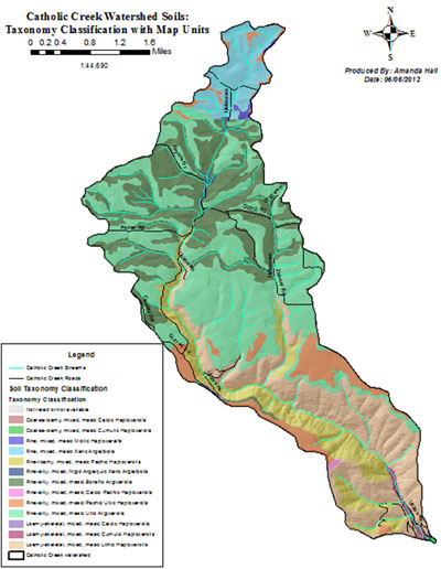
Soils
Primary soils in the canyon portion of Catholic creek are the Lickskillet-Alpowa-Rock outcrop complex and the Linville-Kettenbach association, both dominated by basalts (Figure 5). Slopes range from 45 to 75 percent. As the canyon becomes part of the Palouse Prairie, slopes decrease and soils dominated by loess deepen. Common soils are the Palouse and Naff series, typically found on slopes between 8 and 20%. The Thatuna-Naff-Tilma complex is equally important on slopes between 10 and 25%. (USDA 2004) In the Latah county portion of the watershed typical soils are the Latah silt loam on slopes between 0 and 3%. The Tilma-Naff complex dominates on slopes between 7 and 25% (USDA 1981).
According to the published soil surveys; soils in the watershed are dominated by infiltration rates between 0.5 and 6 inches/hour in the topsoil layers. Recent soil quality data collected by the NPSWCD found infiltration rates to be 55 in/hr for the first foot of conventionally farmed fields and 4 in/hr for the second foot. Direct seed farming practices increased the infiltration of the soils in the first foot to 130 in/hr; and the second foot remained at 4 in/hr. After continuous direct seed had been implemented for up to 10 years the second foot infiltration rate was also increased to as much as 40 in/hr. Increased rates are due to increased aggregate stability and aggregation of the soils.
Bulk density rates in the soil survey and the soil quality data collected by the NPSWCD are reasonably consistent. The soil reaction values (pH) in the soil survey are 6.1 to 7.3. Soil quality data collected in 2002 to 2006 show pH values slightly lower at 5.2 to 6.
There are four map units that are designated as Prime farmland. These are the flatter map units typified by the Palouse silt loam, Naff-Palouse complex, Palouse-Athena complex and the Lapwai-Bridgewater complex. (USGS 2004; and USGS 1981).
Figure 5. Soils map.
Land Use
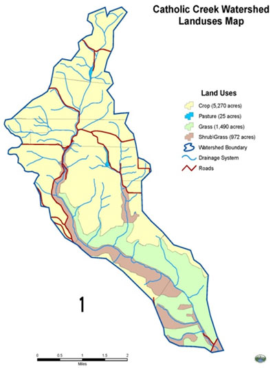
Land use on the upper prairie portion of the Catholic Creek watershed is primarily dry land agriculture (68%), with a fraction dedicated to Conservation Reserve Program (CRP) grasses. The middle canyon portion of the watershed supports grassed hillsides (19%), with a shrub/grass mix lower in the canyon (12%). Table 6 delineates the type of land use, the acreage and the percentage of the watershed dedicated to each use. Figure 6 illustrates the spatial distribution of these uses throughout the watershed (USGS 2001).
Table 6. Catholic Creek Land Use Acreage and Percentages
| Land Use Category | Acres | % |
| Crop | 5,270 | 68% |
| CRP | 3 | 0.04% |
| Pasture | 25 | 0.3% |
| Grass | 1,490 | 19% |
| Shrub/Grass | 972 | 12% |
| TOTAL: | 7,760 | 100% |
Figure 6. Land use designations
Land Cover
Land cover within the watershed, as displayed in Table 7, is divided into nine categories according to land cover GIS data provided by the NPSWCD. Dominant land cover coincides with the dominant land use, with 71% of the watershed covered by cultivated crops (USGS 2001).
Table 7. Catholic Creek land cover extent.
| Cover Type | Acres | % |
| Developed, Open Space | 145 | 2 |
| Developed, Low Intensity | 18 | <1 |
| Deciduous Forest | 49 | 1 |
| Evergreen forest | 158 | 2 |
| Shrub/Scrub | 605 | 8 |
| Grassland/Herbaceous | 1306 | 17 |
| Cultivated Crops | 5545 | 71 |
| Woody Wetland | 1 | <1 |
| Emergent Herbaceous Wetland | 6 | <1 |
| Total | 7831 | 100 |
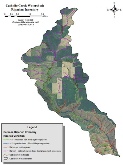
Riparian Areas
A riparian zone is the area immediately adjacent to a lake, stream, river, or other water body. Riparian vegetation is that which is located within the riparian zone, whose success depends upon their roots reaching the water table at some point in the year.
Twenty-nine out of 40 total stream miles have little or no riparian cover. NOAA Fisheries identifies Riparian Condition as one of the most important limiting factors to salmonid productivity. NOAA also lists a lack of large woody debris recruitment as a major contributor to a decrease in salmonid habitat complexity (NOAA 2012). In the agricultural uplands of Catholic Creek, stream segments now surrounded by cropped fields were cleared of vegetation in order to farm. The removal of riparian vegetation has made these stream segments more prone to bank instability and bank erosion, as well as making them more open to solar heat load, and less able to recruit habitat-forming woody debris. Excess heat load reaching Catholic Creek is the main cause of the stream temperature criteria exceedances, and temperature is yet another limiting factor identified by NOAA Fisheries as impairing salmonid productivity. More intact riparian zones exist in the canyon reach, where red alder and cottonwood provide the upper canopy, and shrubs make up the understory (Figure 7).
Figure 7. Catholic Creek Riparian Inventory
Wetlands
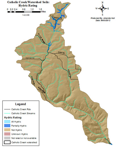
The USDA Soil Survey for Lewis/Nez Perce Counties (2004) was used to determine the extent of hydric soils in the Catholic Creek watershed, most of which are located in the headwater segments (Figure 8). As the following Floodplain section points out, much of the headwaters has been drained and channelized during its conversion to cropland.
The location and assessment of wetlands for restoration and protection is essential for filtrating non-point source pollution related to agricultural practices before it enters headwater tributaries of Catholic Creek. Wetland location in the watershed may significantly affect water storage and, subsequently, flooding. For example, wetlands in the upper watershed may alleviate downstream flooding by intercepting, storing and delaying surface runoff, and reducing peak flows.
In addition to directly providing habitat, wetlands can indirectly support steelhead and other fish species through several functions. Groundwater recharge functions of headwater and floodplain wetlands augment late summer stream flows, which are vital to spawning fish. Wetlands connected to streams containing these fish may also provide winter rearing habitat.
Figure 8. Catholic Creek potential wetland areas.
Water Resources
Both surface and ground water resources are discussed in this section. Surface waters consist of streams, rivers, lakes, reservoirs, ponds and wetlands. Ground water can refer to shallow ground water that filters through the soil until hitting an impervious layer and migrating laterally, often coming back to the surface in the form of a spring. Ground water can also be found in deeper aquifers or in the plumes of groundwater surrounding streams and rivers. Both water quality and water quantity are discussed here.
Surface Water Quality
Water quality parameters were evaluated through a combination of literature research and direct measurements. A handful of agencies and organizations have collected data within the watershed—Nez Perce Tribe (NPT), Idaho Department of Agriculture (ISDA), Idaho Department of Environmental Quality (IDEQ), and the NPSWCD. A summary of the data available from these entities is presented in this chapter. Currently, the Lower Clearwater River Total Maximum Daily Load (TMDL) allocation is complete and moving through the federal approval process. The TMDL effort is led by the Nez Perce Tribe—Water Resources Department in cooperation with the Environmental Protection Agency (EPA).
The State of Idaho Water Quality Standards designate the cold water aquatic life beneficial use for Catholic Creek is. Through a series of agreements with the State and EPA, the NPT has primary jurisdiction over the surface water bodies that flow through the Nez Perce reservation. The NPT designates the following beneficial uses for Catholic Creek: salmonid spawning, cold water biota, primary and secondary contact recreation, primary contact ceremonial and wildlife habitat (NPT 2009). Agricultural water supply is an existing beneficial use of Catholic Creek.
The NPT has found that Catholic Creek is not supporting its beneficial uses, due to the following factors: bacteria, dissolved oxygen, flow alteration, habitat alteration, ammonia, nutrients, organics, sediment and temperature. The NPT lists agriculture and grazing as the two main non-point sources of these pollutants (NPT 2009). The list of pollutants causing impairment of beneficial uses in Catholic Creek corresponds directly with several of the Ecological Concerns NOAA Fisheries identifies as fisheries limiting factors for the region. NOAA Fisheries identifies Increased Sediment Quantity and Turbidity as key limiting factors to salmonid productivity, along with concerns mentioned elsewhere in this document, like Temperature and Altered Flow Timing (NOAA 2012). Historical management actions that altered the natural hydrologic regime (flow) and destroyed habitat also increased the pollutant load to Catholic Creek and caused the physical and chemical impairment found in the watershed today.
The watershed contains steelhead/rainbow trout, speckled dace, and redside shiner. Early studies indicate that Catholic Creek water quality is limited by extreme annual stream flow variation, low summer flow, eroding banks and lack of pool habitat (Fuller 1984). Fuller notes that Catholic Creek is subject to excessive grazing in the lower reaches and intensive agricultural activity in the headwaters. The middle section of the creek is within a steep canyon with well-developed riparian vegetation. Upstream from the mouth, approximately 0.5 mile, the stream flows through a cattle enclosure and small ranch.
Data Gaps
There are many data gaps in water quality data for Catholic Creek. Little flow data was collected for Catholic Creek during the monitoring period, making load calculations difficult. Dissolved oxygen data was also not collected. As this data becomes available, the TMDL will be adjusted as needed.
Toxic Substances
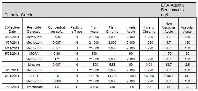
The Idaho Department of Agriculture (ISDA) Pesticide testing program found 12 detections in 2004 – Dicamba, Dimethoate, Linuron, Methomyl, Metribuzin (5), Picloram, Tralkoxydim. There were 10 detections of herbicides and two detections of insecticides. It was noted that a local landowner had been dumping grass clippings along the edge of the creek. These clippings could have contained some of the pesticides that are often found in lawn maintenance products (ISDA 2011).
In 2011 Catholic creek had 10 detections – 2,4-D, Dimethoate, Linuron, MCPA, Metribuzin (6) (Table 9).
ISDA considers a pesticide of concern (POC) any pesticide that is greater than or equal to fifty percent (D50%) of an established EPA aquatic benchmark. Catholic Creek had one herbicide detection (linuron) that was D50% of the chronic invertebrate benchmark, and one insecticide (dimethoate) that exceeded the chronic invertebrate benchmark (Table 19). Catholic Creek had the second highest number of pesticide detections (10) for the study. According to ISDA, the number of pesticide detections correlate well with precipitation levels and timing of applications.
Table 9. Catholic Creek pesticide results.
Pesticides and insecticides can negatively impact salmonids exposed to them. 2, 4-D can cause neurological problems that interfere with swimming and feeding. Insecticides, like Dimethoate, are known endocrine disruptors that can negatively effect fish growth and reproduction (Ries 2012). For these and other reasons, NOAA Fisheries has identified Toxic Contaminants as key limiting factors to salmonid productivity (NOAA 2012).
HydrologyThe Catholic Creek watershed’s hydrologic regime is dominated by rain-on-snow events occurring sporadically from December through April. No gauging station is present on Catholic Creek. USGS StreamStats modeled average annual flow is 1.24 cubic feet per second (cfs)—based on drainage area, precipitation and topography. Modeled annual peak flow is 98 cfs. Low flow is estimated at 0.2 cfs. Peak flow for the 25 year-24 hour storm is estimated at 704 cfs (USGS 2012).
As mentioned in earlier sections of this report, the headwaters of Catholic Creek have been hydrologically modified in order to promote drainage from croplands. Headwater stream segments have been drained and channelized, which creates higher peak flows in the spring by decreasing the headwaters’ holding capacity. The decrease in holding capacity also creates diminished base flows and contributes to lower reaches becoming de-watered entirely during the hottest months of the year. NOAA Fisheries identifies this type of modification to the hydrologic regime as key limiting factors to salmonid productivity—Increased Water Quantity and Altered Flow Timing (NOAA 2012).
Ground Water Quality
According to the Nez Perce Tribe Water Quality Assessment 2009, the primary sources of contaminants to groundwater are agriculture (pesticides and nitrates), and leaking septic tanks (nutrients and bacteria). The pesticide determinations found by the Idaho Department of Agriculture for surface waters are an indicator of possible groundwater contaminations although no actual data for groundwater contamination was found (NPT 2009).
Fish and Wildlife Resources
Fisheries
The lower Clearwater is critical for wild steelhead and fall Chinook salmon within the Clearwater subbasin, including all or a substantial majority of range in the subbasin. Spring Chinook salmon are not known to use the lower Clearwater except as a mainstem migration corridor; likewise bull trout and westslope cutthroat trout use the mainstem Clearwater River. Steelhead were selected as the primary focal species for the Catholic Creek watershed based upon the documentation of their presence within the system.
Status and Importance of Steelhead
Most significant to Catholic Creek and the scope of this management plan are the ESA listed Snake River steelhead (Oncorhynchus mykiss) that currently use the watershed for spawning and rearing. The few electrofishing efforts completed on Catholic Creek found juvenile steelhead in the lower reaches of Catholic Creek though the capture densities were not as high as those in the neighboring streams. The Interior Columbia Technical Recovery Team (consortium of scientists) identifies the Lower Clearwater River and its tributaries as among the few areas in the Snake River basin having predominantly wild steelhead production with limited hatchery influence (NMFS 2006). After researching the available literature, collecting data, and reviewing the existing data on Catholic Creek, the NPSWCD then compared the suite of findings to NOAA Fisheries’ Ecological Concerns, finding direct correlation between several of the fisheries limiting factors identified by NOAA Fisheries and the existing conditions in Catholic Creek. Table 10 shows the NOAA Fisheries Ecological Concerns that apply directly to Catholic Creek. Given the current water and habitat quality in Catholic Creek, steelhead found there exhibit the ability to survive environmental conditions which include frequent droughts and relatively high summer temperatures. A robust population of steelhead possessing the ability to survive such adversities would be of great importance to the region.
Limiting Factors
A technical team of regional scientists selected fourteen limiting factors for the watershed. The technical team selected these factors based upon the data collected for the development of the watershed plan. Table 10 lists the identified limiting factors. The selected limiting factors are discussed below as well as the basis for their selection.
Table 10. NOAA Fisheries Ecological Concerns and Fisheries Limiting Factors for Catholic Creek (NOAA 2012).
| NOAA Limiting Factor |
| 1.1 Anthropogenic Barriers |
| 1.2 Natural Barriers |
| 4.1 Riparian Condition |
| 4.2 LWD Recruitment |
| 5.2 Floodplain Condition |
| 6.1 Bed and Channel Form |
| 6.2 Instream Structural Complexity |
| 7.2 Increased Sediment Quantity |
| 8.1 Temperature |
| 8.4 Turbidity |
| 8.7 Toxic Substances |
| 9.1 Increased Water Quantity |
| 9.2 Decreased Water Quantity |
| 9.3 Altered Flow Timing |
Habitat Condition
As noted in previous sections, the highest level of anthropogenic influence on Catholic Creek occurs in the uplands and is the source of the greatest impacts to the altered hydrology of the watershed. The conversion of the upper watershed to dry land agriculture has contributed to this altered hydrological regime, increasing the intensity of peak flows while diminishing groundwater retention. This, in turn, has led to the series of limiting factors NOAA Fisheries describes as the Ecological Concerns under the Channel Structure and Form category: loss of sinuosity, bank hardening, aggradation and channelization. Restoration efforts in the lower reaches of the watershed will not have the desired effect without moderating hydrological processes in the uplands.
The middle canyon reaches of the system tend to be very steep and deep with a minimum of development, providing a natural buffer from human impact. The lower reaches are impacted by human development and grazing, but still contain attributes like floodplain connectivity, cool water inputs and sections of intact riparian vegetation. With the proper restoration and protection efforts, Catholic Creek could sustain both anadromous and resident fish populations.