Project Description:
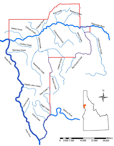
Figure 1. Location of Cottonwood Creek in Nez Perce County.
The Nez Perce Soil and Water Conservation District (NPSWCD) received funds from the Idaho Governor’s Office of Species Conservation through the Pacific Coastal Salmon Recovery Fund to install streambank protection measures along 0.15 miles of Cottonwood Creek (Figure 1). The project is a cooperative effort between the NPSWCD, Nez Perce County and private landowners. This project is a high priority due to its potential to impact steelhead habitat as well as the imminent threat to public safety from road bank erosion.
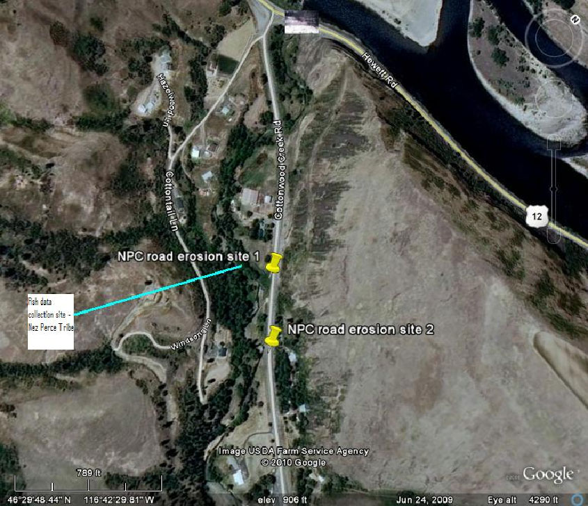
Figure 2. Cottonwood Creek project sites.
Two streambank erosion sites are located adjacent to Cottonwood Creek road (Figure 2). These sites have historically been repaired through dumped riprap. This project proposes a long-term restoration solution utilizing a combination of rock and bioengineering to resolve the problem.
The Cottonwood Creek Watershed encompasses over 41, 000 acres and is located in Nez Perce and Lewis counties, Idaho. The stream enters the Clearwater River approximately 20 miles East of Lewiston, Idaho.
The project site contains Snake River steelhead which were listed under the Endangered Species Act in 1997 as threatened. (1997, 62 FR 43937)
Adult steelhead in spawning condition have been sampled in Cottonwood Creek in the spring (most recently 2009). Substrate sampling indicated that the lower Cottonwood Creek contained adequate spawning substrate for adult steelhead. The Kucera et. al. (1986) study indicated that sampling areas with good canopy cover and stable streambanks support twice the summer and winter density of fish compared to reaches with poor canopy cover. The most recent sampling has been conducted by the Nez Perce Tribe in 2009 as part of their Lower Clearwater Monitoring project. Samples collected included juvenile steelhead/rainbow trout immediately downstream of the project area.
Project Accomplishments:
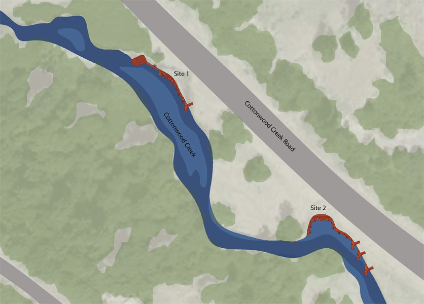
Figure 3. Treatment Locations.
Project construction occurred in August 2011 and included the bank protection of two locations along Cottonwood Creek. These locations were also a risk to the public as they were rapidly eroding into Gifford-Ruebens road. During the week long construction 330 linear feet of streambank were protected, 63 linear feet of biologs and 51 linear feet of brush mattress were installed along the road. In addition 10 rootwads, 3 rock barbs, 238 shrub/tree plantings were placed throughout the site to provide extra bank stability. Once the construction was complete 2.5 acres were seeded to guard against erosion and 640 liner feet of fence was replaced. Project accomplishments are summarized in the Cottonwood Creek Streambank Project Monitoring Report - 2012.
SITE ONE
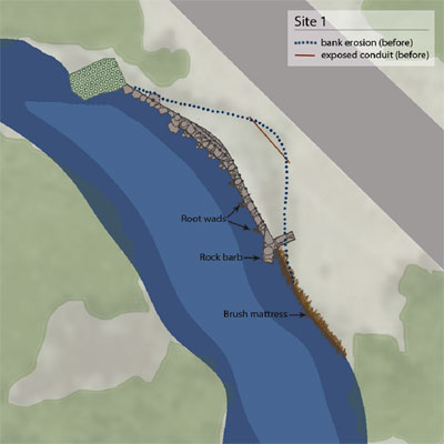
Site one is located 0.40 miles from Highway 12 on Gifford-Reubens Road. Before construction began the bank was rapidly eroding into the county road. A telephone conduit could also be seen due to the vast erosion on the bank. Several practices were installed to protect the bank and prevent future eroding. These practices include the installation of root wads, brush mattress, willow bundles, tree plantings and bank stabilization measures.
SITE TWO
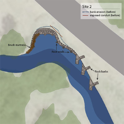
Site two is located 0.46 miles from Highway 12 on Gifford-Reubens Road. Before construction began the bank was also rapidly eroding into the county road. The erosion was so severe that the stream had started to work into the rock base of the road. A telephone conduit could also be seen due to the vast erosion on the bank. Several practices were installed to protect the bank and prevent future eroding including bank stabilization, root wads, rock barbs, bio-logs, willow bundles, and tree plantings.
ROCK BARBS
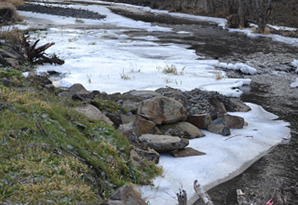
The objective of rock barbs is to help stabilize the stream bank. During high spring flows, when the velocity of the stream scours the stream bank, the rock barbs deflect the velocity and redirect water away from the stream bank. At this project three rock barbs were installed upstream of site two.
BRUSH MATTRESS
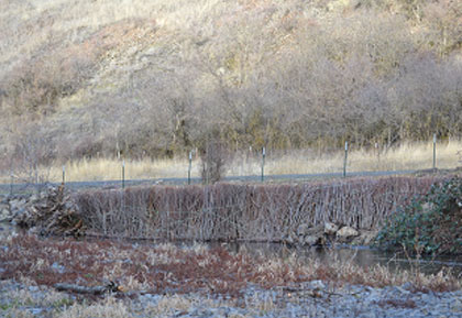
A brush mattress is a layer of live branches placed on a bank face. The live branches are cut from any sprouting woody plant, such as willow. The mattress and the live bundles are held in place with twine, live stakes, and dead stout stakes. The brush mattress has the potential to immediately slow velocities along the bank and accumulate sediment. The brush mattress helps to control bank erosion while serving as habitat for birds, small fur-bearing animals, insects and other organisms that in turn are fed upon by fish and other higher organisms.
ROOT WADS
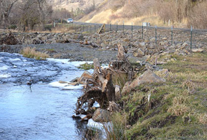
Root wads are a streambank protection technique that provides immediate riverbank stabilization, protects the toe-of-slope and provides excellent fish habitat, especially for juveniles. They provide toe support for bank revegetation techniques and collect sediment and debris that will enhance bank structure over time. Root wads are installed by digging a trench long enough to place the 10-foot stem into the bank and leave just the root wad at the end sticking out. This project included the installation of 10 root wads, 4 root wads at site one and 6 root wads at site two, for bank protection measures.
Project Monitoring:
Fish habitat inventory that was conducted along 2,928 feet of Cottonwood Creek as part of the project. This inventory is part of an effort to establish base-line habitat conditions that will be used to compare with future monitoring efforts.
All data was collected according to the methods outlined in the Cottonwood Creek Fish Habitat Inventory Protocol - 2011. This protocol was adapted from the USDA-Forest Service R1/R2 (Northern/Intermountain Regions) Fish and Fish Habitat Standard Inventory Procedures Handbook. Data was collected by physical field inventory performed in December 2011.
Fish habitat parameters inventoried include habitat type (pool, riffle, run and glide) and the length of each habitat type, left and right bank length, max and average depths, average width, length of stable right and left banks and length of undercut left and right banks as well as large woody debris (singles, aggregates and root wads).
Results
Inventory results are organized into two parts A) Habitat Inventory and B) Large Woody Debris Inventory. Figure 4 illustrates the habitat inventory site location.
A. Habitat Inventory
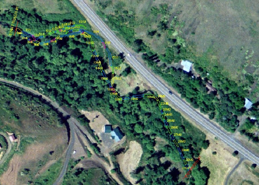
Figure 4. Habitat Inventory results showing habitat unit locations.
A total of 31 main channel habitat units and 20 side channel habitat units were identified during the inventory. Figure 4 illustrates the location of the habitat units within the survey area.
Habitat types
Four habitat types were identified during the inventory: glide, pool, riffle, and run. The riffle habitat type was the most prevalent at approximately 1,900 linear feet or 65% of the total (Table 1). Figure 5 denotes the physical location of each habitat type within the surveyed area.
Table 1. Habitat inventory data.
Habitat
Type | Linear
Feet | % of
total |
| Glide | 320 | 11 |
| Pool | 226.5 | 8 |
| Riffle | 1,877.5 | 64 |
| Run | 504.5 | 17 |
| TOTAL | 2,928.5 |
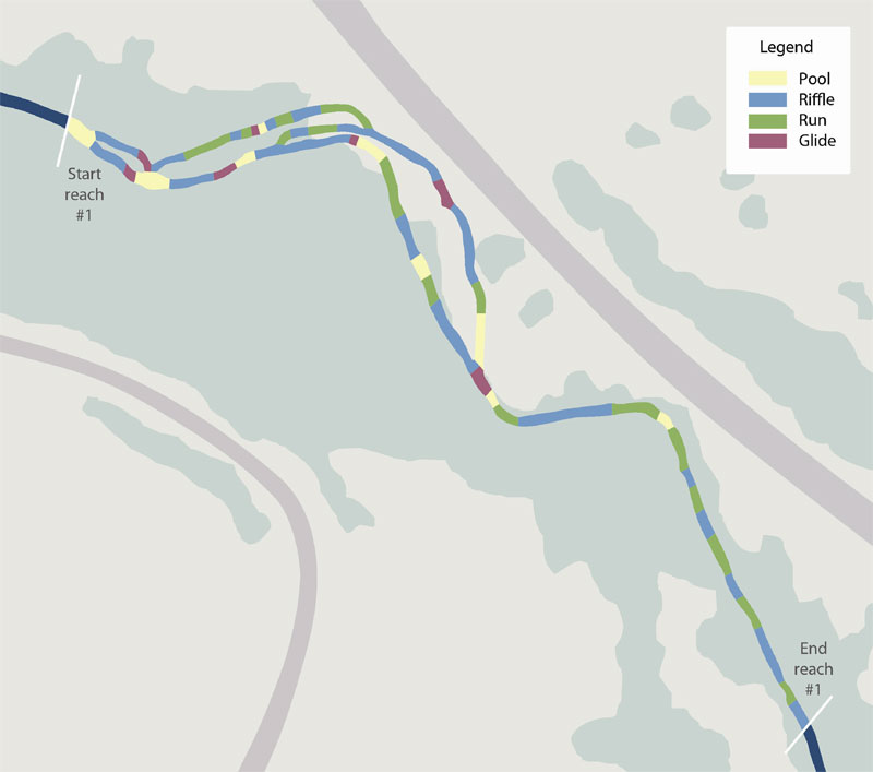
Figure 5. Habitat type locations. (Click on map for larger view)
B. Large Woody Debris
A large woody debris (LWD) inventory was conducted within each habitat unit. LWD data was collected for singles, aggregates and root wads.
A total of 43 pieces of large woody debris were identified during the habitat inventory. The majority of the LWD consisted of rootwads (42%), then singles (23 %) and finally aggregates (19%). Of the 31 habitat units, 42% contained rootwads.
LWD Single Data Summary
All large woody debris that is within the bankfull channel was inventoried. Also included are "spanners" (single pieces of large woody debris that span the width of the stream but are located above the water) if they would potentially be in the water or at the surface at bankfull flow. For length, a single piece must be at least 3 meters (10 feet) in length or must have a length equal to or greater than two-thirds the wetted width of the stream. For diameter, a single piece must be at least 0.1 meters (4 inches) in diameter one-third of the way up from the base.
Five habitat units contained the LWD singles identified during the survey and included habitat units 1, 4, 5, 15, 29 and 31. The number of pieces per habitat unit ranged from one to two.
Single pieces were measured for length, diameter and percent submerged in water. The size ranges from 7.5 feet long to 28 feet long with the largest single pieces found in habitat unit 5 and the highest percent of submerged LWD was found in habitat unit 15.
LWD Aggregate Data Summary
An aggregate represents two or more clumped (in other words, touching) pieces of large woody debris each of which qualifies as a single piece. The majority of aggregates were found in habitat unit 22 (48 pieces).
LWD Rootwad Summary
Rootwads are boles or root masses attached to logs less than 3 meters (10 feet) in length and at least 0.1 meters (4 inches) in diameter one-third of the way up the log.
Rootwads were identified within 13 habitat units.