Details provided in this section were obtained from the 2013 Restoring Anadromous Fish Habitat in the Lapwai Creek Watershed and the 2009 Lapwai Creek Ecological Restoration Strategy.
Location
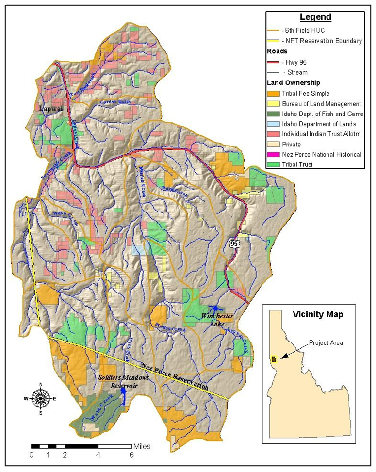
Lapwai Creek, a 4th order stream, includes the tributaries of Mission, Sweetwater, Webb and Tom Beall Creeks (Figure 1). From its origin, Lapwai Creek flows 8.9 kilometers before discharging into Winchester Lake, near Winchester, Idaho. From the outflow of Winchester Lake, the creek continues its northward course for approximately forty-one km and enters the Clearwater River 18 km east of Lewiston, ID. Highway 95 abuts the west bank of the creek from Winchester Lake to stream km 23. Lapwai Creek shows a high degree of channel confinement within this segment due to the combined effects of the highway location and steep, narrow valley.
From stream km 23 to the mouth, the valley widens but confinement remains an issue due to a series of railroad prisms and dikes restricting access to the floodplain. The Lapwai Creek Watershed lies within Nez Perce and Lewis counties, Idaho as well as within the Nez Perce 1863 Reservation boundary. Several small communities, including Culdesac, Sweetwater, Lapwai and Spalding, are located adjacent to main stem Lapwai Creek. Moderate grazing and irrigation activities were noted below stream km 23 with dryland agriculture prevalent throughout the headwaters.
Figure 1. Lapwai Creek Watershed Map
Ownership
Originally intended to be an intact parcel of land for the Nez Perce people, the reservation has legally been open for non-Indian settlement since the General Allotment Act of 1887, also known as the Dawes Act. Unique ownership patterns resulting from settlement in the Lapwai Creek basin lead to diverse land management strategies. Historically, state, federal and tribal lands throughout the reservation have been administered through different avenues, lacking a comprehensive management plan for the benefit of fisheries and wildlife resources, and have thus been unable to direct a unified approach on private land. Through the recent (SRBA), the Tribe is poised to receive title to approximately 11,000 acres of BLM land within the reservation boundaries, including nearly 2,000 acres within the Lapwai Creek watershed; Table 1 reflects the land ownership within the basin following that land transfer. Figure 2 shows Lapwai Creek land ownership.
Figure 2. Ownership map
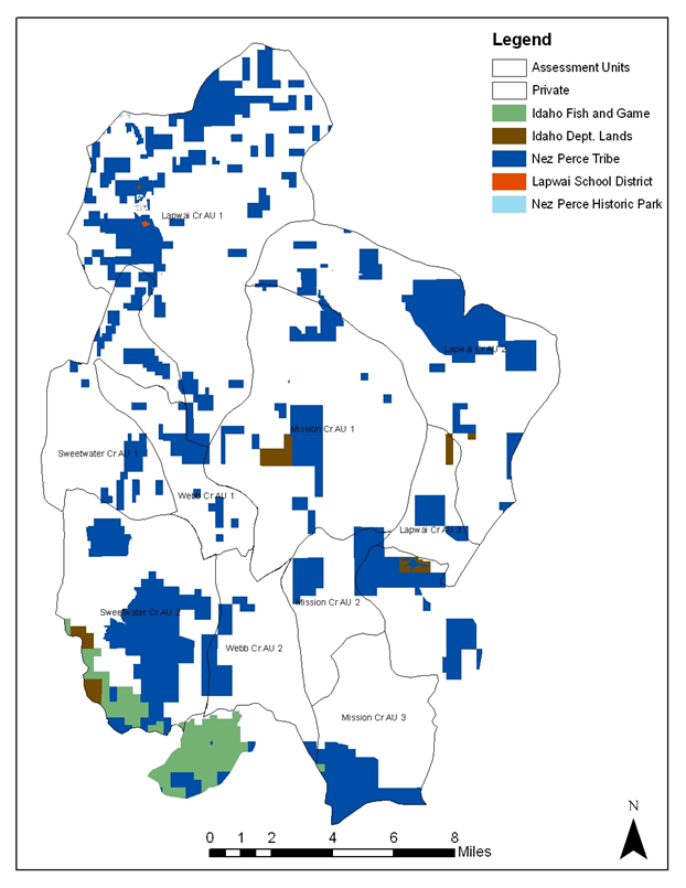
Table 1. Lapwai Creek watershed ownership.
| Ownership | Acres | Percentage (%) |
| Private | 150,000 | 86 |
| Nez Perce Tribe | 22,670 | 13 |
| State Lands | 1,620 | 1 |
| Water | 310 | 0 |
| Total | 174,600 | 100 |
Climate and Hydrology
The region’s climate pattern is maritime-influenced with average annual temperature, precipitation and snowfall increasing with elevation. Climate stations located in Winchester, ID and Lewiston, ID best describe the range of conditions found throughout the Lapwai Creek watershed. Winchester, at a higher elevation, is generally cooler than Lewiston year-round, receiving nearly twice the precipitation and more than five times the snowfall.
Stream flow patterns in the Lapwai Creek drainage are driven primarily by storm events in streams that drain mid and low elevation plateaus, and by the timing and volume of snow-melt from streams draining Craig Mountain. The snowpack on Craig Mountain is an important driver of the hydrology in the Lapwai Creek Basin. Significant amounts of snow accumulate on Craig Mountain in some winters, with peak snow-melt occurring in late winter or early spring. Rain-on-snow events occur in most years, and occasionally cause extreme floods. Droughts are common in years when there is little snow accumulation on Craig Mountain, or when snows melt rapidly in early spring. Historically, melt-water sustained streams flows throughout most of the summer. In recent decades, the entire basin appears to be shifting toward a rain-dominated hydrograph characterized by flashy peaks, and extremely low flows during the summer drought period. The hydrograph is significantly altered by agricultural runoff, water diversions, and manipulation by several reservoirs.
Table 2. Summary of Climatic Conditions Recorded at Winchester, ID and Lewiston, ID (Western Region Climate Center, 2007)
| Climatic Condition | Winchester, ID2 | Lewiston, ID1 |
| Average Annual Temperature (°F) | 43.3 | 52.5 |
| Average Daily Temperature- January (°F) | 27.5 | 33.3 |
| Average Daily Temperature- July (°F) | 61.4 | 74.0 |
| Total Average Precipitation (in) | 24.1 | 12.7 |
| Total Average Snowfall (in) | 93.5 | 15.6 |
1Data set complete from 1965-2005
2Data set complete from 1948-2005
Topography
Streams within the Lapwai Creek drainage generally originate in rolling uplands dominated by dryland agriculture and flow through steeply walled basaltic and granitic canyons as they descend from the uplands. The gradient decreases and the valleys widen in the lower reaches of the watershed (Figure 3.). The watershed is divided nearly in half by a northeast-trending escarpment, creating distinct upper and lower sections of the drainage. Within the Lapwai Creek drainage, the maximum elevation is 1,463m, while the mouth of Lapwai Creek is at an elevation of 239m (description adapted from WSU Assessment, 2001).
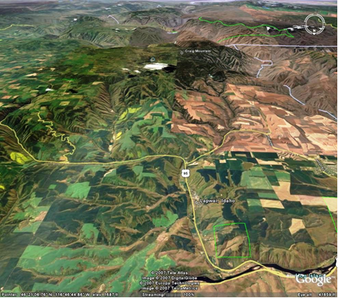
Figure 3. Topography of the Lapwai Creek Watershed
Geology and Lithology
The predominant rock type in the Lapwai Creek watershed is the Columbia River basalt group, consisting of a series of extrusive volcanic flows measuring 2,000 to 4,000 feet in thickness. As many as 17 different flows have been counted with each flow ranging from 25 to 150 feet in thickness. Loess deposits can blanket the basalt above the escarpment with steep valleys carved through the basalts below. A semi-circular band of granitics representative of the Idaho Batholith extends through the upper portions of the watershed. The granitics are centered around Winchester Lake and extend from the Lapwai Creek headwaters through central Mission Creek and southward along the divide between the headwaters of Sweetwater and Webb Creeks (description from WSU Assessment, 2001).
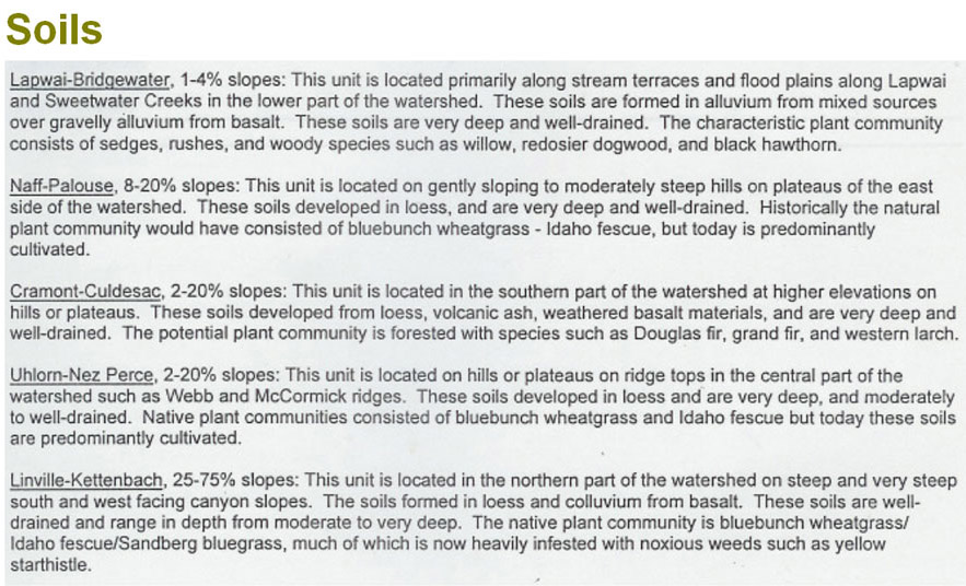
Soils
Figure 4. Soil Types within the Lapwai Creek Watershed.
Land Use and Land Cover
Figure 5. Land use designations
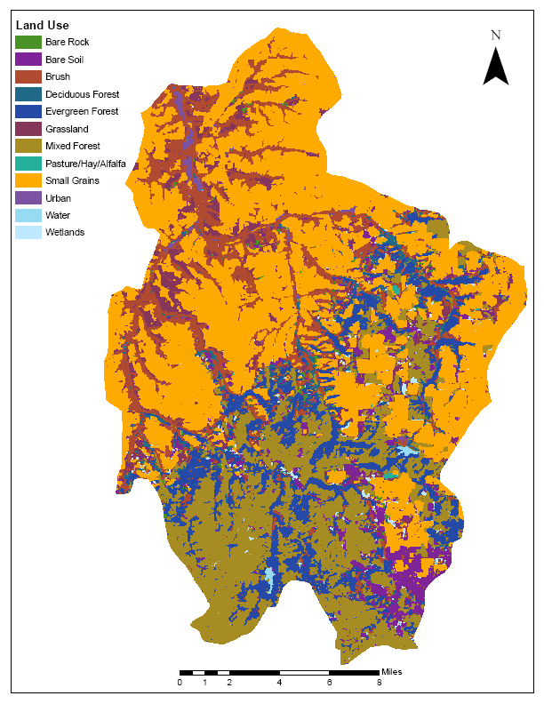
The GIS coverage developed for evaluating land cover within the Lapwai Creek watershed (Figure 5) was obtained from the NPT- Land Services division and excludes two headwater reaches of Sweetwater and Webb Creeks. With the exception of those two sections, the watershed encompasses 158,622 acres. Of this, three land uses dominate 78% of that area. These three land uses— forestry, grazing and agriculture—are somewhat difficult to differentiate because of the transitional nature of the uses. The coverage was examined instead to show the potential for these activities within the basin. Additionally, other conditions such as the physical makeup of the land, historic uses of the land and the accuracy of the digital coverage were evaluated as well. Thus, these figures should be looked at as being relative in nature.
In contrast to many areas with high agricultural use, where fertile river bottoms provide grazing and farming opportunities, the Lapwai Creek basin is dominated by wooded or forested creek bottoms with agriculture concentrated in the surrounding uplands. This provides a unique set of circumstances which, combined with road placement and forestry practices, contributes to highly degraded aquatic conditions throughout the watershed. In addition to the intrinsic value of the natural resources within this area, concerns with cultural resources, endangered species, and tribal traditions factor heavily into management decisions.
Streams within the Lapwai Creek watershed are severely impacted by numerous anthropogenic stressors over the past century. Non-irrigated cropland is present in the uplands surrounding the stream valleys, while grazing and logging activities are prevalent throughout the headwaters and canyons. Paved, gravel, and dirt roads constrict many miles of stream throughout the drainages, and create numerous fish passage barriers at those locations where stream channels are crossed. Streams within the watershed and their associated floodplains have been further restricted by levees constructed immediately adjacent to stream channels, and irrigation diversion structures located within the watershed divert all summer flows from significant reaches of several streams.
These activities have resulted in reduced retention of spring precipitation and summer groundwater recharge in many streams throughout the watershed; increased fine sediment input compounded by diminished riparian buffering capability; decreased stream shading; decreased large woody debris recruitment; discharge of livestock waste into streams; channel confinement with diminished habitat complexity, decreased stream bed stability and reduced dissipation of flood-water energy; reduced and/or eliminated stream flows, and multiple fish passage barriers. Many of these stream impacts are further exacerbated, given the geology and elevation of the watersheds, by highly erosive loess soils and frequent rain on snow events. As such, surveys performed from 1982 to 1983 by the Nez Perce Tribe Department of Fisheries Resource Management (DFRM) found streams within the Lapwai Creek watershed to exhibit extreme annual flow variations (mean summer baseflows frequently falling below 10% of mean annual discharge levels); high summer water temperatures; high levels of sedimentation, cobble embeddedness and bedload; high nutrient and fecal coliform input; and poor quality and quantity salmonid spawning, rearing and over-wintering habitat.
Riparian Areas
Figure 6. Lapwai Creek Riparian Inventory
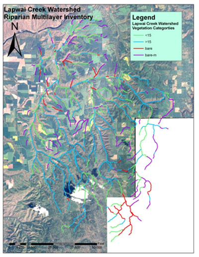
A riparian zone is the area immediately adjacent to a lake, stream, river or other body of water. Riparian vegetation is comprised of both wetland and upland species that are dependent upon their roots reaching the water table and include a variety of native grass, shrub, and tree species, as well as wetland plants like sedges, rushes, and bulrushes. Riparian vegetation currently covers less than 1% of the western United States. The diversity of native wetland and woody plant species, especially when connected to intact upland plant communities, provides outstanding food sources and nesting, hiding, and thermal cover for many fish and wildlife species.
Historically, riparian area vegetation in the Lapwai Creek drainage contained cottonwood (Populus spp.); willow (Salix spp.); birch (Betula spp.); alder (Alnus spp.); red-osier dogwood (Cornus sericea); black hawthorn (Cretaegus douglasii); and mock orange (Philadelphus lewisii). Currently, these species have been displaced by non-native species to varying degrees. Native species tend to dominant at higher elevations, northfacing slopes, and in the more confined canyons. Non-native species become more predominant on drier, south-facing slopes, and in the wider valley bottoms. Native riparian plant communities are generally more diverse than areas dominated by exotic vegetation. Compared to exotic plant species, native riparian species such as sedges, rushes, and willows do a better job of filtering sediments and nutrients. Due to their generally deeper and more extensive root systems, they also provide greater infiltration, higher water tables, and increased streambank stability (K. Werlin, personal correspondence, 2007).
Changing land use in riparian zones has increased the abundance and diversity of noxious weeds in the watershed, which include such species as: yellow starthistle (Centaurea solstitialis), poison hemlock (Conium maculatum), scotch thistle (Onopordum acanthium), perennial pepperweed (Lepidium latifolium), spotted knapweed (Centaurea maculosa), and knotweed species (Polygonum ssp). Idaho has over a hundred weed species present, and non-native, invasive plant species have especially become a major threat to riparian communities (Prather, et al., 2006).
Wetlands
Wetlands, often referred to as “nature’s kidneys,” provide many benefits, including: flood water storage, fish and wildlife habitat, nutrient uptake, ground water recharge and discharge, erosion control, and water quality improvement. Wetlands historically provided many traditional foods (e.g., camas) for the Nimiipuu. There is limited knowledge about the historical extent of wetlands within the watershed, but hydric soils data suggest that a significant percentage of the landscape in the upper watershed was historically wet meadow and other wetland habitat types. Today, wetlands within the Lapwai Creek watershed have been degraded through anthropogenic impacts such as: grazing, road development, timber harvest, farming, and draining. Collection of baseline information to obtain an understanding of how wetlands currently function in the Lapwai Creek watershed has been undertaken by the NPT Water Resources Department. Wetlands can provide support to the Lapwai Creek drainage in many ways including:
- Water Quality Improvement: Agriculture is the predominant land use in the Lapwai Creek watershed, and Lapwai Creek is listed as water quality impaired on the State of Idaho’s 303(d) list for nutrients and sediment. Therefore, locating and assessing wetlands for restoration, enhancement, and protection in the watershed is essential to prevent and/or buffer non-point source pollution from entering the tributaries to Lapwai Creek.
- Flood Attenuation and Desynchronization: Timber harvest and wetland drainage for agricultural purposes have significantly reduced flood retention in the headwaters of Lapwai Creek watershed, resulting in flash floods that damage salmonid habitat (Cichosz et al. 2001 in review). Wetland location in the watershed may significantly affect water storage and flooding. For example, wetlands in the upper watershed may alleviate downstream flooding by intercepting, storing, and delaying surface runoff, and reducing peak flows. Subsequently, the lower flow rate improves the biogeophysical characteristics of adjacent streams. Wetlands in the lower reaches of the watershed, such as the floodplain wetlands along Lapwai Creek, provide storage for water overtopping the banks, and are therefore effective at reducing flood episodes. Mid-elevation wetlands may be most effective at desynchronization (i.e., they attenuate discharge into groundwater and streams allowing a steady baseflow to be released throughout the growing season), since these wetlands are far enough upstream to create delay, yet low enough in the watershed to collect significant amounts of water.
- Groundwater Recharge and Discharge: Timber harvest and wetland drainage have had negative impacts on water storage in the upper reaches of the Lapwai Creek watershed, which has reduced the seasonal duration of streamflow in tributaries to Lapwai Creek. Groundwater recharge functions of headwater and floodplain wetlands augment late summer stream flows, which are vital to spawning fish.
- Fish and Wildlife Habitat: Many wildlife species including birds, mammals, reptiles and amphibians inhabit the Lapwai Creek watershed. Almost all of these wildlife species use riparian and/or wetland areas at some stage in their life cycle. Salmonid spawning and rearing occur within all major tributaries to Lapwai Creek. Of the anadromous salmonids, Hé-yey (O. mykiss) are best suited to the Lapwai Creek system, and have been recorded in all major tributaries to Lapwai Creek. Wetlands connected to streams containing anadromous fish may provide winter salmonid rearing habitat. In addition to directly providing habitat, wetlands can indirectly support fish through many of the functions explained above.
- Evergreen and Mixed Forest: Timber and wood products form a significant portion of the region’s economy (Nez Perce County online brochure, 2007). It is difficult to discern the exact amount of timber harvest or logging that occurs because of the mix of ownership throughout the basin. Much of the timber in the area is located in the uplands, making harvest problematic, or is mixed in with deciduous forest, making selection challenging. The GIS coverage in Figure 5 indicates that approximately 27% of the watershed is comprised of timber that has the potential to be pursued as harvestable. Grassland and Brush: While grazing can occur on a variety of land types, grassland and brush best typify grazing areas in the Lapwai area (L. Ames, correspondence, 2007). The combined acres of grassland and brush make up 11% of the watershed; as with forestry, however, many other conditions influence where animals are actually grazed, including slope, aspect, time of year and weather. Additionally, feeding operations in the Lapwai drainage often occur within a 300’ riparian buffer4 along streams, creating an additional impact.
- Agriculture: By far the greatest land use in the Lapwai basin, and the land use with the greatest associated certainty, is agriculture. Small Grains, combined with Pasture/Hay/Alfalfa, comprise 40% of the Lapwai Basin. The primary consideration in determining how much of that 40% is cropped depends on the time of year and whether it is in rotation. Cropping may also occur in other land types, such as historic wetlands or within a 300’ riparian buffer.
Water Resources
At the time of this writing, no information was available on actual versus permitted water use in the Lapwai Creek drainage. During the 2006 Snake River Basin Adjudication (SRBA), all water rights and claims to surface and ground water were inventoried. The combined permitted in-stream, pond, spring and groundwater water withdrawals have the potential to dewater several streams in the Lapwai Creek watershed (L. Rasmussen, NPSWCD, 2007); however, many of these water rights appear to have been exercised rarely, if ever.
The early 1900’s marked an advent of water resource development in the Lapwai Creek watershed with two projects having particular significance.
Winchester Lake- In 1910, the Craig Mountain Lumber Company created Winchester Lake (or Lapwai Lake) by damming the headwaters of Lapwai Creek, forming a mill pond that was used until about 1966, when all of the marketable-sized timber had been extracted. The largest and most expensive mill of its kind in northern Idaho, Craig Mountain Lumber Company employed up to 270 men and provided electric power to the town of Winchester during its early years (Nielson, 1980). Currently, Winchester Lake has sedimentation and water quality issues, effecting Upper Lapwai Creek (TMDL, 1999).
Lewiston Orchards Project- The Lewiston Orchards Project (LOP) was constructed by private interests beginning in 1906, to bring irrigation water to the southern part of Lewiston. Comprised of four diversions on Sweetwater, Webb, West Fork Sweetwater and Captain John Creeks, as well as a number of canals, feeders and three reservoirs, the LOP provides irrigation and/or domestic water to nearly half of the residents of Lewiston, primarily in the once-agricultural Orchards residential area. The LOP is owned by the Bureau of Reclamation (BOR) and is operated by the Lewiston Orchards Irrigation District (LOID).
Long term flow requirements for this system are under development in anticipation of the BiOp, slated to be in place by January 31, 2010. Interim flow requirements for the LOID project allow the removal of all but 2.5 cubic feet per second (cfs) in Sweetwater Creek at the diversion and all but 1 cfs in Webb Creek. Prior to operation of the numerous diversion structures throughout Sweetwater Creek and its tributaries, the Twenty One Ranch springs maintained summer flow at between 3 and 10 cfs, augmenting flows in both Sweetwater and Lapwai Creek (Morehead, 2004).
The Twenty One Ranch springs historically had a significant impact on the amount and temperature of summer flow into Sweetwater and Lapwai Creeks. The 2001 NOAA Fisheries BiOp indicated that Sweetwater Creek was “likely of very high biological value” as it provided refuge from summer drought due to the input from the springs. Data taken throughout the last century indicate that the springs output between 1.6 and 11.1 cfs ranging in temperature from 8.3°C-10.6°C with an average temperature of 10°C, well within the optimal thermal range for salmonids and other aquatic resources.
Toxic Substances
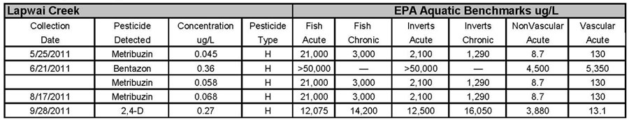
The Idaho Department of Agriculture (ISDA) Pesticide testing program found 5 detections in Lapwai Creek in 2011– 2,4-D, Metribuzin (3) and Bentazon (Table 3).
ISDA considers a pesticide of concern (POC) any pesticide that is greater than or equal to fifty percent (D50%) of an established EPA aquatic benchmark. Lapwai Creek had one herbicide detection (Metribuzin) that was D50% of the chronic invertebrate benchmark. According to ISDA, the number of pesticide detections correlate well with precipitation levels and timing of applications.
Table 3. Pesticide Results for Lapwai Creek..
Hydrology
Hydrologic Alteration: In 1965, following an extremely high flow event during which Lapwai Creek reached flows of ~4,000 cfs, the US Army Corps of Engineers (USACE) completed a flood control project placing a series of levees along Lapwai Creek near the unincorporated town of Sweetwater, ID. Later that year, flood control structures were completed along Mission Creek as well. Flood control projects continued into the 1980’s, including: channel straightening and enlargement; rip rapping banks; levee construction; and snagging and clearing (WSU Assessment, 2001). Alterations such as these disrupt natural flow regimes, often leading to increased peak flows and reduced low flows. This can impact sediment transport and deposition, channel stability, habitat complexity and quantity, water temperature, and aquatic biota production and diversity (WSU Assessment, 2001).
Historically, flows in this basin may have been variable but grow increasingly inconsistent. The SCS Engineering Computer Program for Project Formulation – Hydrology showed an estimated 267% increase in the 10-year, 24-hour storm peak discharge (Environmental Assessment for Mission-Lapwai Creek Watershed, 1994). For that 10-year 24-hour storm peak discharge rate, the model estimated an approximate presettlement discharge of 1,800 cfs and a discharge rate of 6,600 cfs under current land cover and use. Since 1975, the highest discharge recorded at the USGS gage at the mouth of Lapwai has been 5,010 cfs on February 9, 1996 (WSU Assessment, 2001).
Fish and Wildlife Resources
Fisheries
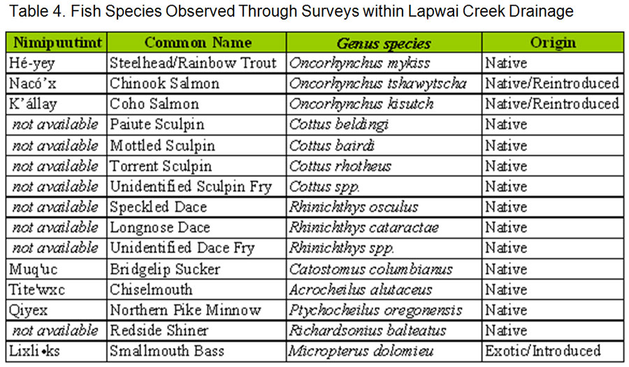
Lapwai Creek provides habitat for a variety of resident and anadromous fish species. Fish observed in Lapwai Creek include species listed in Table 4. The anadromous stocks include wild A-run Hé-yey (steelhead (Oncorhynchus mykiss)), fall- run Nacó’x (Chinook salmon (Oncorhynchus tshawytscha)) and recently reintroduced K’állay (coho salmon (O. kisutch)). The Tribe has began a recovery effort for Heesu, or anadromous lamprey (Lampreta tridentata), often referred to by the Nimiipuu as eels. According to oral tradition, Heesu are a species of previous and enduring significance within this drainage.
The majority of the Lapwai Creek drainage is federally designated as critical habitat for the Snake River Basin Steelhead DPS. The Snake River Basin Steelhead DPS is a December 2005 continuance of the August 1997 62 FR 43937 ESU (evolutionary significant unit) listed as threatened under the Endangered Species Act. The Snake River fall chinook ESU was listed as threatened under the Endangered Species Act on December 28, 1993 (58 FR 68543).
Table 4. Fish Species Observed Through Surveys within Lapwai Creek Drainage.
A robust data set exists within the watershed that shows Hé-yey (steelhead or O. mykiss) distribution and relative abundance throughout the entire Lapwai Creek drainage. Hé-yey habitat requirements, relative to other fish species in the watershed, are fairly specific. Habitat conditions adequate for supporting productive populations of Hé-yey will help ensure high-quality habitat for other aquatic biota as well; in this way, they may be considered an “indicator” species.
STATUS AND IMPORTANCE OF STEELHEAD
Local oral histories of the Nez Perce Tribe refer to the region’s once significant salmon runs. Like many anadromous streams in the Columbia River Basin, populations of anadromous fish species have declined significantly from historic levels. Stories told of this area describe fish so thick within Sweetwater Creek that children caught them in gunnysacks and men didn’t have to travel to the Clearwater because they could catch enough fish for their families in Lapwai Creek. Traditions of harvesting salmon, Muq’uc or suckers (Catostomus spp.) and resident fish are discussed in Salmon and His People (1999), a written history of the Nimiipu’s interaction with fisheries resources throughout time.
A 2006 Biological Opinion issued by NOAA Fisheries states that the steelhead population utilizing Sweetwater Creek, a Lapwai Creek tributary with a historically high volume of cool spring-fed flow, was likely a “significant and unique” or “source” population for the Clearwater basin during times of low flows in the years prior to Sweetwater Creek irrigation diversions. Irrigation diversions notwithstanding, comparisons of electrofishing data sets for the Lapwai Creek and Potlatch River basins reveal that juvenile steelhead capture densities observed within the Lapwai Creek (Chandler, C.A., and Parot, R. J. 2006, Chandler C. A. 2006) watershed in 2003 and 2004 were as high as or higher than those noted within concurrent and comparable electrofishing surveys of the productive Potlatch River basin (Bowersox, B. and Brindza, N. 2006). The Technical Recovery Team for this area recognizes that within the Snake River Basin, the Lower Clearwater River and its tributaries are among the few areas with predominantly wild fish production and limited hatchery influence (2006 NOAA LOID/BOR BiOp).
Significantly, wild Hé-yey of the Lower Clearwater basin have seemingly adapted to survive abnormally warm water temperatures. High juvenile Hé-yey densities have been recorded within monitoring sites in which summer water temperatures exceeded 20º C (68º F) on a daily basis while low densities have been found within the boundaries of a Lapwai Creek monitoring site in which water temperatures as high as 31.8º C (89.2º F) were recorded. In light of current global climate forecasts, a robust population of steelhead possessing the ability to survive such adverse water temperatures would ostensibly be of great importance to the region.
Limiting Factors
Six limiting factors identified through the surveys listed above as having the greatest impact on salmonid habitat rehabilitation within the Lapwai Creek drainage were: flow, temperature, habitat diversity, sedimentation, water quality and passage. These limiting factors are corroborated by earlier work by Kucera (1983) and NRCS (2000). Each limiting factor is described below in terms of how it affects salmonids in general, how it specifically applies within the basin, and what the most favorable conditions for salmonids of different life stages are in each category.
Specific habitat needs for salmonids vary throughout the year and different life stages. While regional aquatic habitat data is only available for the summer season, mitigation of the primary limiting factors recognized within this watershed will serve to promote the continued existence of native resident and anadromous species.
Flow: The effect of the amount of stream flow, or the pattern and extent of flow fluctuations within the stream reach on the relative survival or performance of salmonids describes flow. Flow reductions or dewatering due to water withdrawals will be included as part of this attribute. This limiting factor can affect all life stages throughout the year.
All streams in the Lapwai basin appear to have been affected by severely altered flow regimes. Hydrologic profiles for this watershed are characterized by low duration, high intensity spring flow events and exceptionally low summer base flow levels. Rheic flow values recorded near the mouth of Lapwai Creek ranged from 1,420 cfs to 1.2 cfs within a six-month period in the first year of habitat monitoring by the Tribe. Discharge data recorded near the mouth of Lapwai Creek from 1975 to 2008 indicates summer base flows have diminished significantly in the last 30 years.
Regional hydrology is thought to have shifted from moderated spring and summer flows derived from prolonged snowmelt periods which peaked in May or June, to the current pattern of intense spring runoff and diminished summer flow produced by rain and snowdriven systems which typically peak in March or April. The cause of this shift is likely due to multiple factors, beginning with warmer winters and accelerated snowmelt profiles due to agriculture and forestry practices. High spring flows have been further exacerbated by diminished wetland and riparian vegetation area, increased impervious surface area, an increased drainage network (ditching, roads, culverts), stream channelization and reduced floodplain storage, agricultural activities and timber harvest. These same factors also reduce groundwater recharge, which further diminishes low summer base flow. Summer discharge has also been reduced throughout a number of streams by irrigation withdrawals and domestic water use, while rheic base flow has been further diminished, or lost in many areas due to severe bedload deposition incurred during the intense spring-flow events.
With spring events that provide both periods of extremely high flow (exceeding that preferred for salmonid migration) and greatly diminished flow (below that preferred for salmonid migration), the abrupt hydrology within this watershed can decrease the Low Summer Flow Conditions duration of ‘trigger’ flow for both adult and juvenile migration while potentially dewatering redds located outside of the stream thalweg.
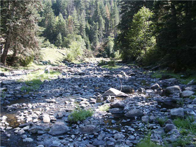
2006 Mission Creek Mid-basin Survey Site Showing Low Summer Flow Conditions
No less important, altered flow regimes are inexorably linked to many of the other limiting factors within this watershed, particularly temperature, habitat complexity, and sedimentation. Summer water temperature, as well as habitat complexity, is affected not only by decreased summer flows, but by channel conditions incurred through extremely high spring flows. Likewise, fine sediment recruitment may increase not only directly through higher spring flows, but through increased shear stresses found under high flow conditions (Rosgen, 1996). Temperature and habitat complexity are also impacted through sustained reductions in base flow incurred through withdrawal of stream flows for irrigation and domestic use, most significantly, those flows diverted from Webb and Sweetwater Creek by the Lewiston Orchards Irrigation District (LOID) for residential irrigation and domestic use.
The Lewiston Orchards Irrigation District (LOID) removes a significant amount of flow from the Lapwai Creek basin via a network of Bureau of Reclamation diversions and canals for residential irrigation and domestic use. The NPT is working closely with LOID and the Bureau of Reclamation to develop Sweetwater and Webb Creek instream flow requirements for a NOAA Fisheries Biological Opinion on LOID actions.
Temperature: The effect of the relative in-stream thermal condition on fish species. This limiting factor is especially important to fish in the incubation and rearing stages, and during low summer flows.
Thermally impaired conditions have been observed throughout most streams of the Lapwai Creek watershed during the months of July and August. Daily maximum temperatures in many of the stream reaches populated by juvenile steelhead have been recorded in excess of 20º C for numerous consecutive weeks with daily maximum temperatures exceeding 23º C recorded for periods of several consecutive days (Chandler and Parot, 2003; Chandler, 2004; Chandler, 2005).
Figure 7. 2005 Thermograph for Mouth of Lapwai Survey Site (LM1).
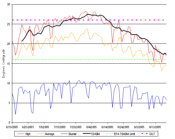
Diurnal=Daily Maximum value minus Daily Minimum value.
7DADM=Average of Daily Maximum value for seven consecutive days.
7DADM Limit= 16°C for Juvenile Salmonid Core Rearing Habitat
UILT= 26°C Upper Incipient Lethal Temperature for Juvenile Salmonid Rearing
(24 hour exposure = 50% mortality) 6 During the 2003 survey season, the NPT Monitoring and Evaluation project found that the EPA- recommended seven day average daily (7DADM) maximum limit of 16°C was exceeded throughout 75% of sites surveyed within the Lapwai Creek drainage. All 16 sites sampled within the Lapwai Creek watershed exceeded the 7DADM maximum in 2004, while 14 out of 16 sites failed to meet the EPA criteria in 2005. Figure 7 displays 2005 thermal data collected at a monitoring site located near the mouth of Lapwai Creek.
Salmonid species are particularly temperature-sensitive during the juvenile life-stage. A 16°C maximum seven day average daily maximum (7DADM) is recommended through US Environmental Protection Agency Region 10 guidance for juvenile salmonids in a core rearing area (EPA 1996). Regional adaptations of a National Marine Fisheries Service watershed condition matrix utilized by local U.S. Forest Service and Bureau of Land Management Offices have classified temperatures above 17.8 °C 7DADM as poor quality juvenile salmonid rearing habitat (BLM et. al 1998, NMFS 1995). Observations have been made, however, of juvenile steelhead and Chinook salmon that remained healthy within an Idaho stream that attained daily maximum temperatures of 24 °C for brief periods of the day, but had low evening temperatures of 8-12 °C. (Bjornn and Reiser, 1991).
High summer water temperatures may result from increased stream width-depth ratios, diminished rheic baseflow due to water withdrawals, reduced groundwater recharge, or unstable channel conditions. These temperatures may also result from reduced canopy cover due to levee development, road prism encroachment, and agricultural and silvicultural activity. Elevated summer water temperatures tend to concentrate the distribution of juvenile steelhead to stream reaches benefiting from spring, groundwater, or hyporheic recharge, thereby reducing ‘available’ habitat to a fraction of the watershed’s habitat potential.
Canopy cover provided from intact riparian communities intercepts and diffuses solar insolation, moderating thermal shifts from radiant heat. Data from 2003 and 2004 NPT distribution surveys indicate that canopy cover throughout the four primary stream of the Lapwai Creek watershed varied from as little as 5% in sections of Mission and Lapwai Creeks, to as high as 97% in upper Sweetwater Creek. These extremes were reflected in stream averages as well, with Mission and Lapwai Creeks having moderately low canopy cover values on average as well, while canopy cover on Sweetwater and Webb Creeks was generally more intact.
Table 5. Canopy Cover
| Lapwai Creek Canopy | Mission Creek Canopy |
Average - 31%
Median - 25%
High - 85%
Low - 5% | Average - 38%
Median - 32%
High - 85%
Low - 5% |
| Sweetwater Creek Canopy | Webb Creek Canopy |
Average - 68%
Median - 80%
High - 97%
Low - 15% | Average - 55%
Median - 60%
High - 75%
Low - 10% |
Habitat Diversity: The effects of physical habitat attributes within a stream reach on relative fish survival or performance. This limiting factor is important for all life stages throughout the year, but especially critical for newly hatched and rearing salmonids. Essentially, species living within diverse habitats have a greater chance to survive and flourish (Mt. Hood Aquatic Assessment, 2006). Habitat needs vary greatly by life-stage, daily activity (feeding, resting, hiding), seasonal activity (actively metabolizing vs. overwintering), and hydrologic condition (baseflow vs. high flow event). Habitat diversity, largely a function of gradient, channel confinement, riparian function and large woody debris, is a limiting factor in most of the Lapwai drainage reaches. Several of the reach lengths are highly confined by railroad prisms, U.S. Highway 95, or other roads. In these reaches, confinement has resulted in decreased complexity, including the following: decreased sinuosity leading toward increased gradient and uniform bedload, reduced riparian width and density which leads to decreased thermal insulation, cover and organic input, as well as reducing large woody debris recruitment. Additionally, because of some land use practices, many of the Lapwai Creek drainage reaches are currently disconnected from their floodplain, resulting in habitat diminished both in quality and size.
The “flashy” hydrograph of the Lapwai Creek watershed has led to increased stream energy, while the ability of the channel to make natural adjustments has diminished due to levees and other flood control measures. As a result, processes of meander formation through scour and deposition no longer function to form series of pools and riffles. Instead, bedload becomes deposited uniformly throughout the channel, creating uniform bed topography that is higher than the water table in late summer. In the case of reduced or altered flow, fish will tend to use pools primarily, followed by runs and then riffles (Bjornn and Reiser, 1991). Stable pools cannot form in many segments of the Lapwai Creek drainage due to confinement of the channel within relatively straight stream banks reinforced for flood control. Floodplain restoration is a crucial element necessary to reestablish geomorphic processes that create and maintain pools. The importance of pools in the Lapwai Creek watershed is great due to increased frequency of drought conditions where pools are the only portions of the stream that remain below the water table.
Substrate composition is critical for spawning and incubation, resident and juvenile anadromous fish cover, and habitat for macroinvertebrates utilized as food sources. As one aspect of habitat diversity, substrate is an indicator of habitat quality but is not currently identified through data analysis as a limiting factor. Distribution and Abundance surveys conducted in 2003 and 2004 by the NPT identified dominate substrate types for the four primary streams in the Lapwai Creek drainage. This information helps form a more complete view of habitat diversity, as various sizes of substrate serve different functions within the stream channel.
Table 6. Creek Substrates
| Lapwai Creek Substrate | Mission Creek Substrate |
Boulder - 16.3%
Coarse Gravel - 26.1%
Cobble - 48.6% | Coarse Gravel - 17.0%
Boulder - 20.0%
Cobble - 32.0% |
| Sweetwater Creek Substrate | Webb Creek Substrate |
Boulder - 10.7%
Coarse Gravel - 28.6%
Cobble - 54.1% | Boulder - 14.0%
Coarse Gravel - 26.6%
Cobble - 49.4% |
Habitat availability is the amount of space a salmonid species will occupy and is determined by habitat diversity and quality, food availability, suitability of substrate for spawning, and presence, size, and behavior of nearby species. Fish densities within a stream are not uniform, but rather increase and decrease relative to the above parameters. During the summer months, when reduced flow and high temperatures limit fish access to and availability of adequate cool water refugia, pool structures are critical. Surveys of habitat diversity throughout the four primary streams within the Lapwai Creek watershed were conducted in 2003 and 2004 by the NPT. Overall, rates of pool habitat were fairly low throughout, indicating reduced cover and cool refugia for salmonids:
Table 7. Creek Habitats
| Lapwai Creek Habitat | Mission Creek Habitat |
Pool - 6.6%
Glide - 27.2%
Riffle - 65.9% | Pool - 4.9%
Glide - 30.7%
Riffle - 64.4% |
| Sweetwater Creek Habitat | Webb Creek Habitat |
Pool - 2.8%
Glide - 32.6%
Riffle - 64.6% | Pool - 7.8%
Glide - 8.5%
Riffle - 83.7% |
Cover and productivity are important at all life stages, emergent fry to spawning adults require cover in different forms to avoid predation and conserve energy otherwise expended in undeflected streamflow. Many of the same aspects that offer cover, such as undercut banks, large woody debris, streamside vegetation, rocks, and logs also act as sources of organic input critical to primary and secondary productivity. Streams lacking instream cover may show a decreased number of pools, decreased depth and surface area, increased velocity and decreased fish biomass (Bjornn and Reiser, 1991). Data from the 2003 and 2004 NPT distribution surveys indicate that the four primary streams within the Lapwai Creek watershed showed moderate canopy cover throughout.
Assuming that LWD is part of a stream’s functional background, a lack of LWD as a result of reduced riparian density may lead to decreased productivity in a stream (Bjornn and Reiser, 1991). Within the Lapwai Creek watershed, a lack of intact riparian vegetation leads not only to reduced primary production, cover and solar insulation, but reduces LWD recruitment and subsequent channel roughness. Across the 16 sites surveyed by the NPT, more than half (56%) lacked woody input large enough to be characterized as LWD in 2003. In 2006, approximately 32% of the surveyed sites lacked LWD, indicating low recruitment.
Sediment Load: The effect of the amount of fine sediment present in, or passing through, a stream reach on the relative survival or performance of fish species. This limiting factor is important during spawning, incubation and rearing.
Waters with high concentrations of suspended sediments result in high levels of turbidity, which can delay migration. Excessive amounts of sediment can embed free matrix cobble and gravel, reducing the amount of available spawning substrate. Additionally, sedimentation in areas where redds have been created can cause suffocation of eggs prior to emergence and reduce available interstitial substrate space for juvenile cover. Natural events, such as landslides or wildfires can contribute to high turbidity, as can unnatural and man-made events, such as poor road placement, and logging or trans-basin diversion.
Although data regarding total suspended solids and turbidity is spatially and temporally inconsistent within the basin, surveys performed by the NPT in 2003 and 2006 indicated moderate to severe impairment of bank stability throughout all 16 sites over both sample years. This is likely to contribute to the overall levels of turbidity and suspended solids.
While a small amount of cobble embeddedness data has been compiled throughout the Lapwai Creek watershed, the physical parameters required in order to collect acceptable cobble embeddedness samples are very narrow, resulting in a 50% survey rate of sites in 2003 by the NPT and a 56% survey rate in 2006. In 2003, of the sites surveyed, 62.5% showed highly impaired conditions, and 25% showed moderate impairment. In 2006, 57% indicated high impairment and an additional 29% were considered moderately impaired. A complete description of methods and results are available by request from the NPT.
Juvenile salmonids tend to avoid streams with regular high turbidity, which can disrupt feeding and territorial behavior. Typically, juvenile fish are not significantly impacted by low or infrequent levels of turbidity, such as those that occur following a storm event. Favorable turbidity levels for juvenile salmonids are < 50 NTU for newly emerged fry and <60 nephelometric turbidity units (NTU) for older fry and parr (Bjornn and Reiser, 1991).
Water Quality: This describes the effects of water’s chemical and biological characteristics on production and survival. This limiting factor affects all life stages throughout the year.
Analysis of water quality data, including dissolved oxygen and phosphorus, may indicate impaired conditions within much of the Lapwai Creek watershed. Many of these water quality issues are exacerbated under low flow and extreme stream water temperatures. Within the Lapwai Creek watershed, all 16 sites monitored in 2003, 2004 and 2005 by the NPT had phosphorus levels in excess of water quality standards established by Idaho DEQ, with the exception of two sites on Mission Creek in 2004. Dissolved oxygen (DO) concentrations, a product of water temperature, velocity, surface and intragravel oxygen exchange, and oxygen demand of organic materials, can greatly affect the swimming performance of migrating salmonids. Minimum levels of DO required for spawning are spawning fish are no less than 5.0 mg/L and at least 80% saturation, according to Bjornn and Reiser (2001). Lower DO levels in redds were correlated with percent survival and size; newly hatched alevins are able to detect and seek out higher levels of DO. Cobel (1961, as cited by Bjornn and Reiser, 1991) concluded that intragravel dissolved oxygen must average 8 mg/L for embryos and alevins to survive well.
After reviewing numerous studies, Davis (1975) stated that a dissolved oxygen concentration of 9.75 mg/L is fully protective of larvae and mature eggs, while at mg/L the average member of the incubating population will exhibit symptoms of oxygen distress, and at 6.5 mg/L a large portion of the incubating eggs may be affected. Bjornn and Reiser (1991) reviewed numerous references and recommend that dissolved oxygen should drop no lower than 5 mg/L, and should be at or near saturation for successful incubation. Low DO concentrations of <5 mg/L adversely affect food conversion efficiency, swimming performance, and growth in juvenile salmonids. Fish affected by low levels of DO may be further stressed by the warm water temperatures that often accompany low DO (Bjornn and Reiser, 1991).
In the 2003 survey year, NPT found that 7 (43.75%) of 16 sites sampled showed levels of DO lower than optimal survey levels. DO levels in concurrent years were somewhat better, with just 12.5% of sites showing severe impairment in both 2004 and 2005.
Diatom samples were collected by the NPT at 16 monitoring sites in the Lapwai Creek basin. The samples were analyzed and scored on a variety of parameters used to indicate water quality. These scores were then summed to provide a multimetric index score of impairment in comparison to unimpaired stream values established by Idaho DEQ. In the 2003 survey year, one site showed little or no impairment, two showed high levels of impairment and the remaining 13 showed moderate impairment. In 2004 and 2005, all sites but one (2005) showed moderately impaired conditions.
Connectivity: The effect of impaired access to crucial areas of aquatic habitat upon the rearing and survival of focal species. This limiting factor is critical for spawning, rearing and migration.
Fish passage, or the ability of fish to access quality habitat, is of concern within the Lapwai Creek watershed because of the high levels of infrastructure within 300 feet of the stream. The abundance of roads, railroad prisms, dikes and levees has resulted in barriers to fish passage for both adults and juveniles. Some are ephemeral or seasonal, while others are year-round or otherwise permanent barriers.
In 2004, the NPT conducted a survey of passage barriers within the Lapwai Creek watershed and found barriers to passage on the mainstems of Lapwai, Mission and Sweetwater Creeks, three of the four major streams in the watershed8. While Webb Creek lacked any mainstem diversions, a natural barrier measuring 12m in height is present at stream km 14.8, effectively blocking steelhead passage (Taylor, E.E., 2004). While natural barriers, including debris jams, waterfalls and excessively high water velocities, can be insurmountable to fish at certain times, many salmonids can navigate past them, given suitable depths at the foot of barriers (Bjornn and Reiser, 1991).
For proper function, all man-made barriers to fish passage should be addressed to provide passage for all life stages of all species at a minimum of 100-year flood event flows (NPT DFRM Strategic Management Plan, 2007, draft). Man-made barriers such as dams, culverts or other diversions may require fish-specific modifications to enable passage; optimally, bridges would be used in place of in-stream modifications (Bjornn and Reiser, 1991).