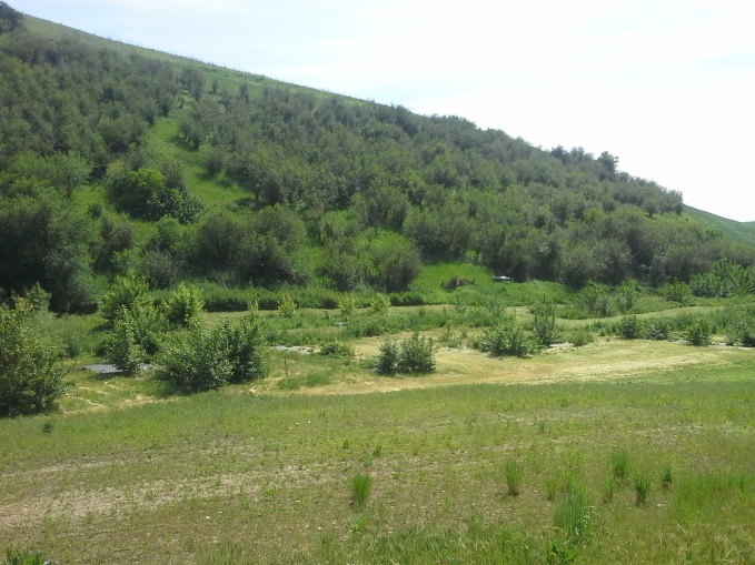
South Tom Beall Creek Riparian Buffer Project
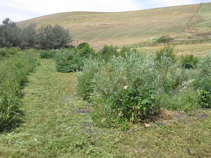
This site is located within the geographical priority unit defined as LC1 in the Lapwai Creek Ecological Restoration Strategy (2009). This site is a component of the South Tom Beall Buffer Implementation Plan which was developed in 2011. The site is a 1.25 mile long stream segment that did not have a vegetative buffer. Prior to implementation of this plan, the site was impacted by agricultural tillage practices adjacent to and within the stream channel. Due to the size of the stream segment, habitat restoration has been completed in phases. Phases I – V plantings occurred in years 2012 – 2016, respectively. The vegetative plantings included grass, forbs, shrubs and trees in order to address fish habitat limiting factors such as high stream temperatures, sedimentation, nutrients, and lack of in-stream habitat complexity and diversity. Plantings are installed within the riparian zone or the transition zone between aquatic and upland habitat within the Tom Beall Creek floodplain. These plantings will assist in restoring the floodplain to properly function conditions, provide wildlife cover and forage enhancement, erosion control and soil stabilization through a reduction in run-off. Approximately 5.29 acres of riparian area planting, 1.17 acres of wetland revegetation, and 6 acres of grass seeding have been installed in order to provide a buffer to filter nutrients and sediment, provide stream shade and stabilize the streambank. The implementation included the following types of vegetation planted at the restoration site: dormant hardwood cuttings, rooted trees, shrubs, and forb stock, and/or grass and forb seed. The plants were installed in a pattern and spacing that mimics the natural vegetation in the vicinity.
Figure 1. South Tom Beall Creek Riparian Buffer Project - 2011
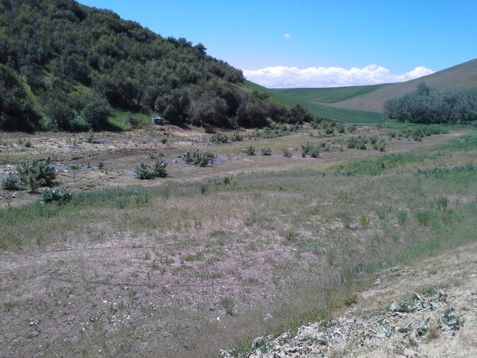
Figure 2. South Tom Beall Creek Riparian Buffer Project - 2017
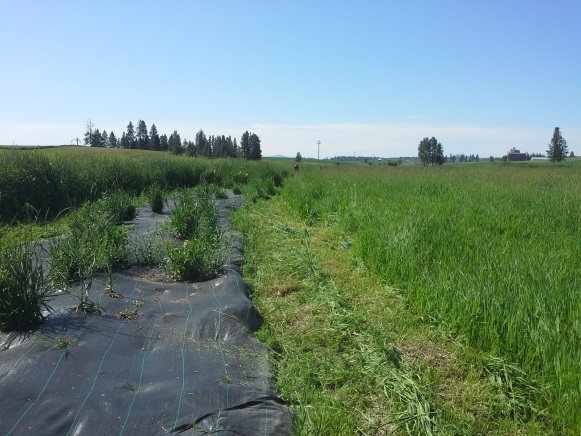
North Reubens Riparian Planting
This site is located within the geographical priority unit identified as LC2 in the Lapwai Creek Ecological Restoration Strategy (2009). The North Reubens Riparian Project covers 1.25 miles, the 1.25 mile reach will be installed in phases due to budget constraints. The site identified in Phase I is currently impacted by agricultural tillage practices adjacent to and within the stream channel. Phase I plantings included 500 LF of stream vegetative plantings which included grass, forbs. shrubs and trees in order to address fish habitat limiting factors such as high stream temperatures, sedimentation, nutrients, and lack of in-stream habitat complexity and diversity. In 2015, the District planted a total of 1.00 acre of native trees/shrubs and grass. The plantings were installed within the riparian zone or the transition zone between aquatic and upland habitat within the Rock Creek floodplain. These plantings were installed above the average high watermark, or bank full height. The riparian vegetation will assist in restoring the floodplain to properly functioning conditions, provide wildlife cover and forage enhancement, erosion control and soil stabilization through a reduction in run-off. Implementation of these plantings will assist in meeting the Lapwai Creek Steelhead Habitat Restoration Plan objectives which include reducing stream temperatures, improving aquatic habitat complexity and diversity, and reduction of instream sedimentation.
Figure 3. North Reubens Riparian 2015
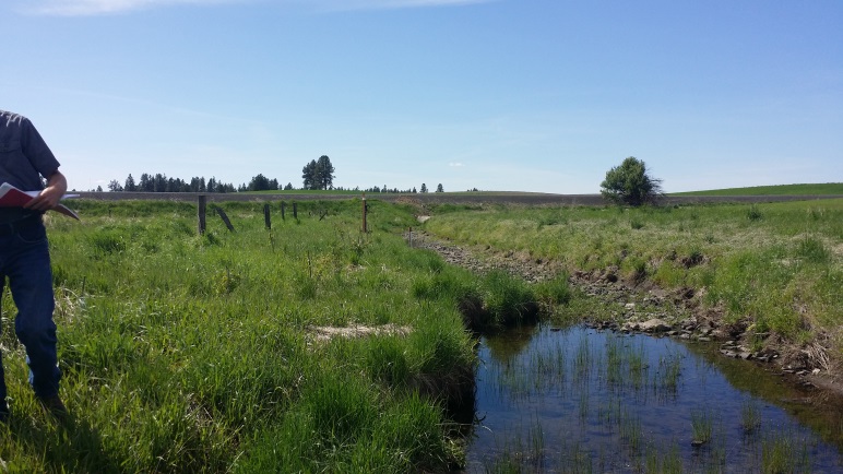
Figure 4. North Reubens Riparian 2016
Tom Beall Floodplain Reconnection
This site is located within the Tom Beall Creek watershed, a tributary of Lapwai Creek in Nez Perce County, Idaho. This project will relocate 0.23 miles of South Tom Beall Creek to its original channel. The stream channel was moved in the late 1970s to a location on the south side of South Tom Beall Road. The relocated channel is unstable, causing annual erosion into the road bank and downcutting. The landowner used the original channel area as a feedlot until 2003, when the feedlot was relocated. The area was surveyed and determined that the original channel profile was not filled or modified. Construction for this project is estimated to occur in 2017/2018.
Mission Creek Bridge Replacement
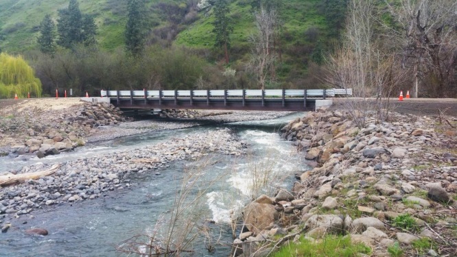
This project is phase two of a five phase project to restore the floodplain in the Mission and Rock Creek watersheds. Phase two replaced an existing bridge on Mission Creek that caused seasonal fish barriers due to flow restriction. The existing 40 LF bridge was replaced with a prefabricated 80 LF bridge. The existing bridge was considered a partial and/or ephemeral barrier. The bridge restricted flow causing bedload to be deposited upstream of the structure. The bedload created a lack of connectivity between the upstream and downstream segments of Mission Creek. The barrier was flow dependent, meaning that the barrier did not exist when flows rose above the bedload. Based on photo point monitoring and a review of historic bridge monitoring reports, it appeared that the barrier occurred on an annual basis with the majority of blockage occurring in the months of June through September. This seasonal barrier prevented juvenile fish from migrating upstream and downstream during the highest stream temperature months. The replacement bridge is wider than the 47 LF bankfull width and the 71 LF flood prone width allowing unrestricted flow.
Mission Creek Bridge Replacement Proposal Information
Figure 5. Mission Creek Bridge 2014
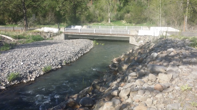
Figure 6. Mission Creek Bridge 2017
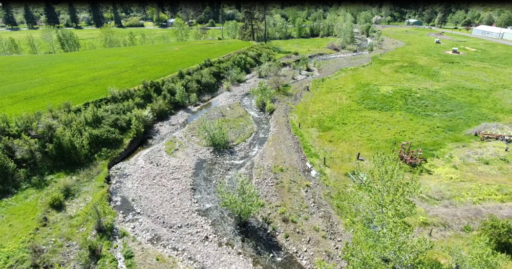
Rock Creek Floodplain Restoration
This project is phase three of a five phase project to restore the floodplain in the Mission and Rock Creek watersheds. Phase three will install fencing to restrict livestock access to the stream, install large woody debris to increase floodplain roughness, and install streambank protection measures.
Figure 7. Rock Creek Floodplain 2017
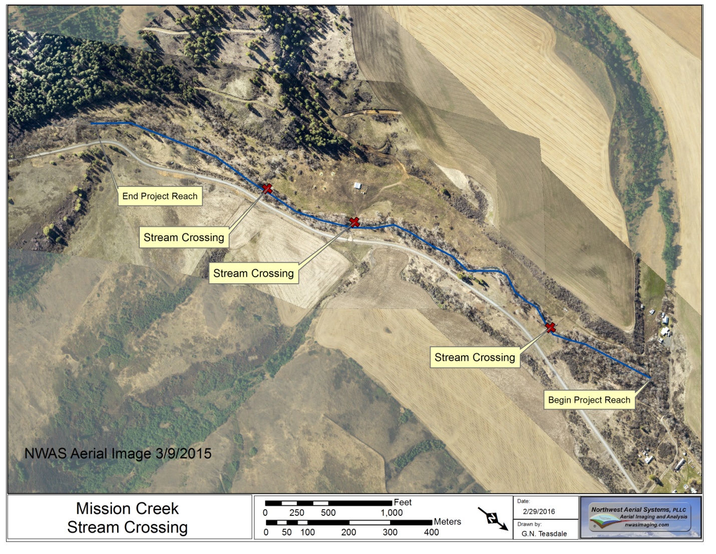
Mission Creek Streambank Erosion and Stream Crossing
This site was identified as a high priority in 2013 as a segment of stream with unstable channel, excessive bank erosion, inadequate riparian area, and inadequate landowner access. This project was selected for analysis and preliminary concept plan development in order to address the identified issues and meet objectives identified in the Lapwai Creek Ecological Restoration Strategy (2009).
The project begins below the limestone quarry on Mission Creek and continues downstream to the private landowner bridge located on Goechner Lane. Currently, the project focuses on the private land portions of the stream. The Nez Perce Tribe has been contacted to determine their interest in inventory and analysis work being performed on the segments identified as trust lands.
Figure 8. Mission Creek Streambank Erosion and Stream Crossing
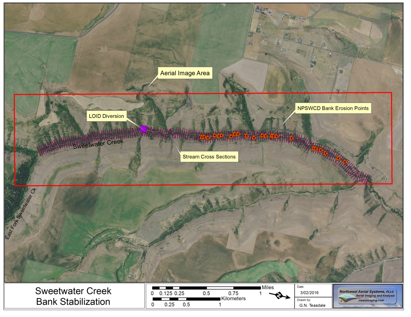
Sweetwater Creek Streambank Erosion and Stream Crossing
This site was identified as a high priority in 2013 as a segment of stream with unstable channel, excessive bank erosion, inadequate riparian area, and inadequate landowner access. This project was selected for analysis and preliminary concept plan development in order to address the identified issues and meet objectives identified in the Lapwai Creek Ecological Restoration Strategy (2009).
The project begins at the confluence of East and West Fork Sweetwater Creek and continues downstream to the confluence of Packers Gulch with Sweetwater Creek. Currently, the project focuses on the private land portions of the stream. The Nez Perce Tribe has been contacted to determine their interest in inventory and analysis work being performed on the segments identified as trust lands. A detailed streambank erosion inventory was completed in 2014 along the private land holdings of the project reach.
Figure 9. Sweetwater Creek Streambank Erosion and Stream Crossing
Riparian Zone Noxious Weed Control Treatments
In the summer the District treats up to 100 riparian acres for weeds in Nez Perce County. Sites are visited and treated by scalping, weed eating, and spraying. The target species are poison hemlock and the target areas included those most visited by people to prevent spread. The sites treated are part of an on-going effort to improve fish habitat in the Lapwai Creek Watershed. By working to control the poison hemlock and other invasive weeds at these sites, it is the District’s goal to reduce the instream temperature and improve the riparian corridor. This project was funded by the Bonneville Power Administration Columbia Basin Fish and Wildlife Program and the Idaho State Department of Agriculture Noxious Weed Program.
2017 End of Year Report
2016 End of Year Report2015 End of Year Report2014 End of Year Report2013 End of Year ReportFigure 10. Riparian Zone Noxious Weed Control – Scalping
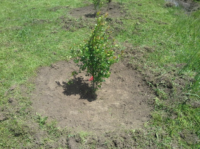
Figure 11. Riparian Zone Noxious Weed Control Mowing
No Till & Conservation Tillage Systems
No till and conservation tillage systems work includes the evaluation of four sites for erosion reduction and water infiltration improvements. Landowners implemented a direct seeding system designed to achieve specified soil bulk density, soil slake, soil electroconductivity (EC), and water infiltration rates. Landowners provided the cost of implementing the system. Lapwai Creek Steelhead Habitat project funds were used for District staff time in providing recommendations and for soil quality evaluations to determine progress in meeting the identified standards. Direct seeding systems reduce erosion by 30 to 80% depending upon the field slope and soil type. Approximately 1,647.3 acres of cropland within the Sweetwater and Tom Beall Creek drainages were seeded with direct seeding systems. Using the District Soil Quality Evaluation Protocol (modified from the USDA's Soil Quality Test Kit Guide Protocol in 2005), District staff evaluated cropland fields that pose a significant erosion and sedimentation risk due to steep slopes, proximity to stream, buffer width, soil texture, and past agricultural tillage and management practices.