Lapwai Creek is located 10 miles east of Lewiston, Idaho and is a tributary to the Clearwater River (figure 1). The watershed originates at Mason Butte in Lewis County. The stream flows north through rolling cropland and pastureland into Winchester Lake at the town of Winchester, Idaho. North of Winchester Lake, Lapwai Creek parallels highway 95 through steep canyons of forest and rangeland. The watershed drains approximately 174,600 acres.
The Lapwai Creek Ecological Restoration Strategy (a watershed management plan) was completed for this watershed in 2009.
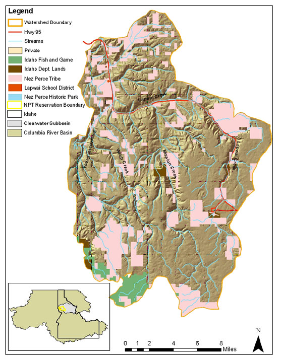
Figure 1. Lapwai Creek Watershed. Click on map to view larger image.
Watershed Improvement Needs:
The watershed improvement activities for the 2014 to 2018 timeframe focus on the following objectives and deliverables:
- Objective 1 – Reduce Stream Temperatures
- Objective 2 – Improve Aquatic Habitat Diversity and Complexity
- Objective 3 – Reduce Instream Sedimentation
Deliverables scheduled for completion in the 2014-2018 time period that will address limiting factors outlined in the Lapwai Creek Ecological Restoration Strategy include:
- Deliverable 1 – Improve Riparian Condition- 4 miles riparian restoration.
- Deliverable 2 – Reduce Streambank Erosion- 1.1 miles streambank stabilization plan development; 800 LF streambank protection.
- Deliverable 3 – Reduce Road Related Sediment Delivery to the Stream-1.5 road improvements, 5.0 miles road improvements planned.
- Deliverable 4 – Reduce Sediment Delivery to Streams from Uplands- 120 acres of upland treatments.
- Deliverable 5 – Remove or Retrofit Fish Barriers- Remove 3 barriers in order to restore 1.25 miles of access.
- Deliverable 6 – Restore Floodplain Access and Reconnect Channel- Complete 7.6 miles of floodplain analysis and restore aquatic habitat suitability to 1,200 feet of stream channel.
- Deliverable 7 – Improve Watershed Hydrology- Install 1.5 acres of wetland enhancements, 40 acres of upland grass/forb planting, and 60 acres of upland tree planting.
In This Section:
- Discover Lapwai Creek
This section describes the watershed’s physical characteristics, history, and provides an introduction to the watershed. - Learn the Issues
This section describes the watershed’s issues including agriculture, fisheries, water quality, and much more... - Resource Library
Find publications, photographs, videos, maps, and data regarding the watershed. - Take Action
Read here to determine how you can help!
Discover Lapwai Creek
Lapwai Creek is a tributary to the Clearwater River and encompasses 174,600 acres of cropland, forestland and grazing land.
In This Section:
- The Watershed
Become familiar with the watershed’s physical characteristics such as soils, streams, plants, animals and infrastructure. - Lapwai Creek 101
Facts about the watershed. - History
- Discover the area’s geological history.
Learn the Issues
The major pollutants in Lapwai Creek include sediment, high stream temperatures, and low stream flows. Learn more about the issues by selecting topics below.
In This Section:
Resource Library
The Nez Perce Soil and Water Conservation District collects resources for public use. Resources include photos, videos, maps, publications and data sets. As these resources become available they are posted here.
In This Section:
- Photos
View photos from the watershed. - Videos
View videos about the watershed. - Maps
View maps relating to the watershed. - Publications
To view the Lapwai Creek documents, Please go to our Publications page. - Data
View available data collected for the Lapwai Creek watershed.
Take Action
Tom Beall Creek Activities
Several projects are in the planning, implementation, or monitoring stage within the Tom Beall Creek tributary of Lapwai Creek. Check out the details below.
Tom Beall Creek Restoration Project - Phase I
This project was completed December 2018 and resulted in the protection of over one mile of stream through the installation of a riparian buffer which resulted in 3,200 feet of streambank protection, installation of 2 stream crossings, 5.14 acres of riparian plantings, and 0.92 acres of wetland enhancement.
Check out the project details on the project page.
White Road Crossing Replacement – Design Phase
This project is slated for completion in 2019 and is for the design of a stream crossing where White Road crosses Tom Beall Creek. The existing crossing is a fish passage barrier. Check out the project details on the project page.
Tom Beall Creek Driving Tour
Take a self-guided tour of Tom Beall Creek and view some of the project activities. Print the tour map and guide below.
Tom Beall Creek Self-Guided Tour