 The Pine Creek watershed is located in North Central Idaho about 20 miles east of Lewiston, Idaho. Pine Creek’s tributaries originate on a rolling plateau that ranges in elevation from 2200 to 2800 feet. The plateau drains into a deep canyon with slopes of 30 to 60% and drops to an elevation of 875 feet at the confluence of Pine Creek and the Clearwater River.
The 16,500 acre Pine Creek Watershed has 13,200 acres of dry cropland, 2,500 acres of range, 500 acres of forest, 425 acres of riparian areas, and the remainder is under miscellaneous use.
Land ownership consists of majority private (16,545). Land use includes non-irrigated cropland (79%), rangeland (15%), forestland (3%), riparian (2%), and other (1%).
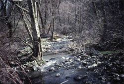
Beneficial uses include agricultural water supply and secondary recreational uses. Low flow and runoff greatly affect the creek’s water quality and in turn affecting habitat for spring steelhead and other cold water species. Run off impacts the stream by producing high nutrients and sediment load which flow into the Clearwater River.
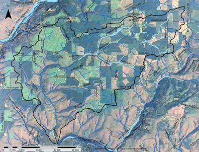
Pine Creek and Hubbard Gulch Watersheds Map
Please go to our Publications page to view the Pine Creek Watershed Documents
Historic Project Activities
In 1985, The District received a grant from the State Water Pollution Control Account to assess water quality and propose remedies for poor water quality in Pine Creek (an Idaho Water Pollution Abatement Plan first priority stream segment). This planning phase determined that accelerated soil erosion caused by conventional agricultural practices degraded Pine Creek and the Clearwater River. Additionally, poor water quality posed an economic and environmental threat to local farmers and the public at large.
From 1985 to 1986, the Lewiston office of the Idaho Department of Health and Welfare Division of Environment (DEQ) conducted an extensive monitoring program on Pine Creek. The status report identified the beneficial uses as agricultural water, secondary contact recreation, salmonid spawning habitat, and cold water biota. The study found that the upper reaches of the watershed contributed a high percentage of nutrients and sediments to Pine Creek. In one year, Pine Creek exported 12,300 tons of suspended sediment into the Clearwater River.
In 1988, implementation of Best Management Practices (BMP’s) began on critical treatment units. BMP’s included tillage, nutrient management, and structural practices. The majority of BMP’s were installed from 1988 to 1992. Structural practices such as grass waterways, sediment basins, grade stabilization structures, and water and sediment control structures, were installed from 1990 to 1998.
In 1998, the District completed a Confined Animal Feeding Operations Inventory and Analysis of the Pine Creek Watershed. Because of such factors as the high concentration of animals with unlimited access to the creek and inadequate containment of feedlot runoff, the District ranked Pine Creek as a stream with a high risk for water quality degradation from livestock activities.
References
Pine Creek State Agricultural Water Quality Implementation Plan. Nez Perce Soil and Water Conservation District. 1996
Pine Creek Watershed Planning Project. Nez Perce Soil and Water Conservation District
Pine Creek Water Quality Report. Idaho Department of Health and Welfare, Environment Division. May 1986.
Created January 2010
Wetlands
The USDA Soil Survey for Lewis/Nez Perce counties was used to determine the extent of hydric soils within the watershed. Approximately 391 acres were identified and are illustrated in figure 2 (shown in light blue).
Figure 2. Pine Creek hydric soils.