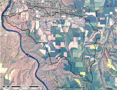
Tammany Creek is a tributary to the Snake River located within Nez Perce County, Idaho (shown as number 20 in Figure 1). The main stem is approximately 13 miles long and includes intermittent and perennial channels. The watershed is approximately 35 square miles and is predominately agricultural land including both cultivated crop and livestock range uses.
Figure 1. Tammany Creek Watershed location.
Watershed Hydrology
Tammany Creek is a second order tributary to the Snake River and is comprised of several minor ephemeral and intermittent stream segments and springs that join to form the creek‘s mainstem. The upper reaches, above the Barr Road crossing in the Tammany area, are intermittent and ephemeral and flow only during heavy precipitation or infrequent snowmelt run off events.
Historically the watershed was primarily rolling grasslands with large woody species such as cottonwoods and willows occupying the stream banks and riparian zones.
Modern land use modifications have resulted in the loss of perennial vegetation through agricultural development, grazing land conversions and roadway and structure construction. This loss in permeability from agricultural and rural development has resulted in larger and accelerated peak flows and reduced base flows in the drier seasons. This has increased sediment delivery to the creek channel and reduced the quality of the aquatic ecosystem.
Stream Channel Assessment
The channel conditions of Tammany Creek vary widely from shallow and wide with well-developed flood plains to highly entrenched with no flood plain. More specifically, the channel classifications according to Rosgen (1994) range from type A6 to C6 in the extreme upper and lower reaches of the creek to type G6 to F6 in the middle reaches. The G6 channel type is representative of a highly entrenched channel with no functioning flood plain and relatively low bank stability. These highly entrenched channels present particularly difficult problems for the control of instream sediment loading and restoration and protection of riparian ecological health. The causes of channel downcutting and entrenchment are difficult to isolate and often result from a combination of factors.
Watershed Geology and Geomorphology
The underlying geology of the Tammany Creek watershed is primarily comprised of silty-loam soils overlying the Lolo flow of the Priest Rapids member of the Wanapum Basalt of the Columbia River Group. Within the drainage there are also exposures on the canyon walls of the Elephant Mountain members of the Saddle Mountain Basalt and associated sedimentary interbeded formations. The creek has eroded into the Lolo basalt and has deposited a bed of alluvium around the creek channel. In various locations throughout the lower extremity of the watershed fluvial deposits of historic meandering of the Snake River and deposition that occurred during the Lake Missoula Flood events that occurred during the last ice age can be observed (Heins, 2001). The upper reaches of the watershed are of low relief topography with a distinct high flat plateau representing the large planar basalt flows that inundated the region. Drainage patterns in the upper region are shallow, have little developed channel structure with most depositing erosional material upon agrading lowland areas. In this region the main stem ephemeral channel of Tammany Creek demonstrates little natural channel development and is primarily a county road drainage ditch. Channel gradients within this region are less than 2%.
The middle reach is gently sloping terrain with limited subdrainage development. The majority of the subdrainages deposit colluvium and alluvium materials upon the agrading lowlands and do not have developed channel delivery to the creek. Channel gradients in this reach vary between 3-5%. The lower reach of the creek exhibits greater channel development and features exposed down-cut basalt along with alluvial deposits from both the creek and historic meanders of the Snake River. The steepest slopes within the drainage are present within this reach with the most comprised of steep and shear basalt exposures. The main channel gradients through this reach range between 5-8% as it descends to the Snake River. All together the watershed is represented by a high plateau which transitions into a low sloping valley that descends more rapidly during the final mile before it reaches the Snake River. Overall this contributes to a very low runoff response to precipitation events with the creek flow dominated by groundwater discharge from the shallow basalt aquifer.
Watershed Climate
The Tammany watershed climate is classified under the Köppen global climate classification system as a Bsk category climate, which can be described as mid-latitude semi-arid, cool steppe regions. The cool classification is on a global scale and yet represents one of the warmest regions within the state of Idaho. More generally, the climate can be characterized as warm and arid with a long growing season. Average annual maximum and minimum temperatures are 63.1 and 41.7 degrees Fahrenheit respectively with an average annual precipitation of 12.5 inches which occurs primarily during the fall through spring seasons with isolated summer thunderstorms. Precipitation is relatively evenly distributed throughout the period between November and June with a monthly average total precipitation of 1.2 inches which commonly occurs in short duration and low intensity precipitation events. The 10-yr. 24-hour precipitation event is estimated to be between 1.7-1.9 inches (NOAA 1975).
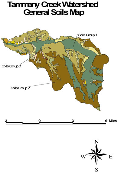
Figure 2. Tammany Creek Watershed General Soils Map
Watershed Soils
Soils within the Tammany Creek watershed were developed in a moderately low precipitation area under grassland conditions. Topsoil depths are estimated to have been in the range of 20-25 inches, but have been reduced by 30-60 percent by erosion under current land practices (SCS 1986). The soils generally have an infiltration restrictive layer at depths of 40 inches, but mechanical cultivation has resulted in shallower restrictive zones in many areas. The soils can be divided into 3 general categories depending upon the slopes that they form upon.
- The Chard silt loam is commonly present on low stream terrace and foothill slopes of 0-4 percent grade and are generally characterized as well and moderately well drained, moderate to moderate slow permeability, a silt loam surface texture and are commonly sodium affected. This group has a current common topsoil depth of 20 inches. Sheet and rill erosion is generally low within this group as the lower slope angles produce less erosion, but gully erosion can occur from concentrated flow originating on higher slopes.
- The soils of the plateau top regions are characterized as silt loams on slopes of 2-8 percent grade that are moderately deep, well drained, have moderate or moderate slow permeability and are commonly sodium affected. Common current topsoil depths within this group are around 14 inches. These areas experience slightly higher erosion potential than that of the drainage bottom or foothill slope soils. Representative soils of this group are the Endicott and Bryden silt loams.
- The soil of the transition slopes between the plateau tops and the drainage bottom soils occur on slopes from 10 and greater percent grade. These soils are also silt loams that are well drained with moderate to moderately slow permeability and experience the greatest erosion through sheet, rill and gully erosion. Representative soils of these areas are the Oliphant, Broadax and Chard silt loams (SCS, 1986).
Within these soil groups, the group three soils present the greatest erosion potential. Within the watershed these soils represent 44% of the soils within the watershed with groups 1 and 2 representing 10% and 46% respectively. The long and low gradient slopes most often present within groups 1 and 2 minimize potential erosion within these regions. Consequently, the greatest sediment contribution from land surface erosion occurs within the group 3 soils.
Watershed Land Uses
The dominant land uses within the Tammany watershed are dryland agricultural crop production, livestock grazing and rural and urban development. Agricultural crop production accounts for approximately 89% of the watershed area of 22,332 acres with range and suburban following with 5% and 6% respectively. Slopes range from 0-40 percent throughout the watershed with slopes between 0-7 percent constituting over 55% of the watershed with slopes greater than 27 percent representing only 5% of the watershed. The dominant agricultural practice is dry land farming of spring and winter wheat and other grain crops. In addition, several small irrigation operations and water rights exist within the watershed.
Water Quality Concerns
Tammany Creek was listed on the 1994 State of Idaho Water Quality Limited List by the EPA for excessive sediment levels. The Tammany Creek Total Maximum Daily Load (TMDL) identifies the current sediment loading and the reductions necessary to bring the creek into full support of its beneficial uses.
Due to the extensive rural and agricultural development within the Tammany Creek watershed, surface and stream bank erosion have been determined to be the dominant source of sediment loading to Tammany Creek. As required by the Clean Water Act, a TMDL was developed which identified the maximum sediment loading that is allowable by State of Idaho water quality criteria. The TMDL analysis focuses on the Idaho water quality standards that are intended to provide protection of all designated beneficial uses for the water body. The beneficial uses for Tammany Creek are secondary contact recreation and the support of cold water biota.
In addition, a draft TMDL implementation plan was developed in July 2003. This plan identifies actions needed to achieve load reductions set forth in the TMDL.
Sediment Source Inventory
Sediment sources within the Tammany Creek watershed have been identified as sheet and rill erosion from crop and grazing lands, pasture land surface runoff, unpaved roadway runoff, rural development activities, animal feeding operations, wildlife stream bank damage and direct stream bank erosion. The most significant sediment sources have been identified as sheet and rill erosion on agricultural lands, surface runoff from rural developments and stream bank erosion. Due to the difficulty in separating the exact source of overland flow sediment, rural development runoff and agricultural land runoff are combined in what will be termed land surface sheet and rill erosion. There are no point-sources in the watershed; therefore all pollutant sources are considered non-point sources.
Water Quality Data
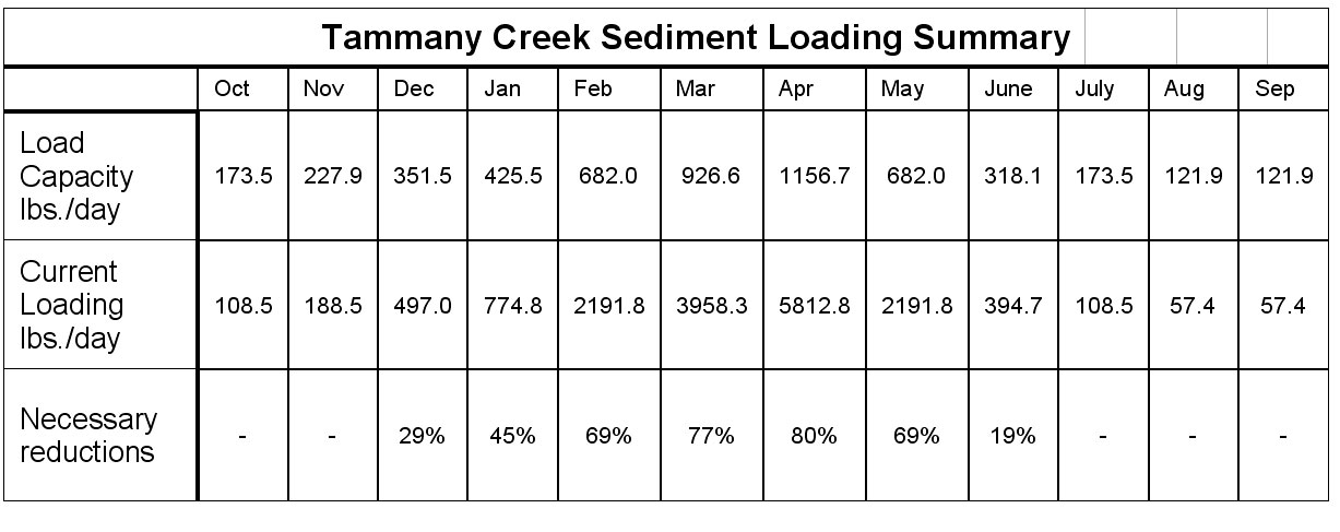
The Tammany Creek TMDL has been developed through the combination of field surveys, water quality data analysis, modeling of hydrologic and erosional processes and application of State of Idaho water quality standards. From these surveys and analyses it is estimated that 11% of the current sediment loading within the Tammany watershed is representative of background levels. The analysis results, shown in Table 1, indicate that there is a 7-month window during high flow periods when sediment loading must be reduced to bring Tammany Creek into compliance with state water quality standards to restore and protect full support of its designated beneficial uses.
Table 1. Sediment Loading Summary.
Wetlands
The USDA Soil Survey for Lewis/Nez Perce counties was used to determine the extent of hydric soils within the watershed. Approximately 456 acres were identified and are illustrated in figure 2 (shown in light blue).
Figure 3. Tammany Creek hydric soils.